IMAGES TAKEN NEAR TO
Parkside Road, CLEATOR MOOR, CA25 5HE
Introduction
This page details the photographs taken nearby to Parkside Road, CA25 5HE by members of the Geograph project.
The Geograph project started in 2005 with the aim of publishing, organising and preserving representative images for every square kilometre of Great Britain, Ireland and the Isle of Man.

There are currently over 7.5m images from over14,400 individuals and you can help contribute to the project by visiting https://www.geograph.org.uk
Image Map
Images are licensed for reuse under creativecommons.org/licenses/by-sa/2.0
Notes
- Clicking on the map will re-center to the selected point.
- The higher the marker number, the further away the image location is from the centre of the postcode.
Image Listing (4 Images Found)
Images are licensed for reuse under creativecommons.org/licenses/by-sa/2.0
Image
Details
Distance
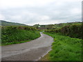
1
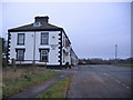
Parkside Hotel.
A new venue for a quiz team I am told.
Image: © John Holmes
Taken: 11 Dec 2005
0.15 miles
2
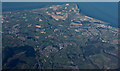
St Bees Head from the air
Cleator Moor is in the foreground, Whitehaven is on the coast to the right, Egremont is on the left.
Image: © Thomas Nugent
Taken: 31 Aug 2015
0.15 miles
3
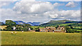
Eastward towards Ennerdale from near Cleator Moor
A fine panorama of the mountains around Ennerdale, seen from A5086 Cleator - Frizington road by Holbeck Farm. To the left is Murton Fell (1,461 ft.), Blake Fell (1,626 ft.), then Great Borne (2,018 ft.) and Starling Dodd (2,077 ft.) shining in sunlight NE of Ennerdale Water, while rather nearer on the right is Grike (1,556 ft.) joined to the Ennerdale Fells which line the south side of Ennerdale Water.
Image: © Ben Brooksbank
Taken: 8 Jul 1986
0.16 miles