IMAGES TAKEN NEAR TO
Victoria Street, CLEATOR MOOR, CA25 5AS
Introduction
This page details the photographs taken nearby to Victoria Street, CA25 5AS by members of the Geograph project.
The Geograph project started in 2005 with the aim of publishing, organising and preserving representative images for every square kilometre of Great Britain, Ireland and the Isle of Man.

There are currently over 7.5m images from over14,400 individuals and you can help contribute to the project by visiting https://www.geograph.org.uk
Image Map
Images are licensed for reuse under creativecommons.org/licenses/by-sa/2.0
Notes
- Clicking on the map will re-center to the selected point.
- The higher the marker number, the further away the image location is from the centre of the postcode.
Image Listing (6 Images Found)
Images are licensed for reuse under creativecommons.org/licenses/by-sa/2.0
Image
Details
Distance
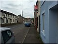
2
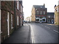
Cleator Moor Main road Junction.
No the 55 shop is not a food shop but a flower shop.
Image: © John Holmes
Taken: 11 Dec 2005
0.14 miles
4
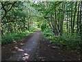
Cycle Route 71 goes through a green tunnel at Cleator Moor
Image: © David Medcalf
Taken: 7 Jul 2022
0.22 miles
6
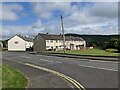
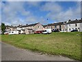
Houses in Cleator Moor
Complete with a large Union Jack.
Image: © David Medcalf
Taken: 7 Jul 2022
0.25 miles