IMAGES TAKEN NEAR TO
Durdar Road, CARLISLE, CA2 4TT
Introduction
This page details the photographs taken nearby to Durdar Road, CA2 4TT by members of the Geograph project.
The Geograph project started in 2005 with the aim of publishing, organising and preserving representative images for every square kilometre of Great Britain, Ireland and the Isle of Man.

There are currently over 7.5m images from over14,400 individuals and you can help contribute to the project by visiting https://www.geograph.org.uk
Image Map
Images are licensed for reuse under creativecommons.org/licenses/by-sa/2.0
Notes
- Clicking on the map will re-center to the selected point.
- The higher the marker number, the further away the image location is from the centre of the postcode.
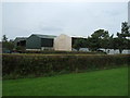
Image Listing (7 Images Found)
Images are licensed for reuse under creativecommons.org/licenses/by-sa/2.0
Image
Details
Distance
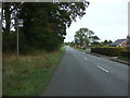
3
Leaving Durdar
A view looking to the north along the lane from Durdar to Carlisle.
Image: © Phil Williams
Taken: 17 Feb 2007
0.13 miles
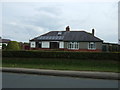
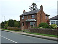
4
Beech hedge outside #483 Durdar Road
There is a rock in the hedge at its left hand edge on which Ordnance Survey records indicate that a rivet benchmark levelled at 70.519m above Newlyn Datum was verified in 1972
Image: © Roger Templeman
Taken: 15 Dec 2021
0.14 miles
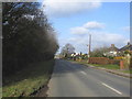
7
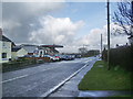
Durdar Road, Durdar
Looking north from the crossroads towards Carlisle
Image: © Alexander P Kapp
Taken: 24 Feb 2008
0.23 miles