IMAGES TAKEN NEAR TO
Low Moor Avenue, CARLISLE, CA2 4SX
Introduction
This page details the photographs taken nearby to Low Moor Avenue, CA2 4SX by members of the Geograph project.
The Geograph project started in 2005 with the aim of publishing, organising and preserving representative images for every square kilometre of Great Britain, Ireland and the Isle of Man.

There are currently over 7.5m images from over14,400 individuals and you can help contribute to the project by visiting https://www.geograph.org.uk
Image Map
Images are licensed for reuse under creativecommons.org/licenses/by-sa/2.0
Notes
- Clicking on the map will re-center to the selected point.
- The higher the marker number, the further away the image location is from the centre of the postcode.
Image Listing (19 Images Found)
Images are licensed for reuse under creativecommons.org/licenses/by-sa/2.0
Image
Details
Distance
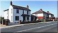
1
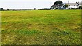
Recreation ground and Low Moor Avenue houses
Image: © Luke Shaw
Taken: 21 Jul 2021
0.03 miles
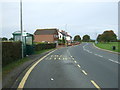
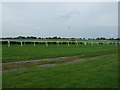
2
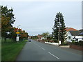
Bend in the road at Blackwell
Looking uphill towards Carlisle Racecourse.
Image: © Rose and Trev Clough
Taken: 26 Aug 2007
0.04 miles
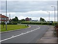
3
Bus stop and shelter on Durdar Road
Looking north.
Image: © JThomas
Taken: 10 Oct 2015
0.05 miles
4
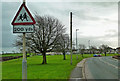
Blackwell Common
Blackwell Common and Durdar Road, photographed in disappointingly poor January light.
Image: © Mary and Angus Hogg
Taken: 23 Jan 2016
0.06 miles
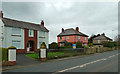
5
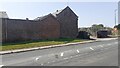
Houses on east side of Durdar Road, opposite recreation ground
Ordnance Survey records indicate that a benchmark levelled at 48.091m above Newlyn Datum was verified in 1972 on the front of the nearest house (#124) on its left hand corner. The house is now pebbledashed.
Image: © Roger Templeman
Taken: 21 Jul 2021
0.08 miles
7
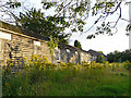
Disused timber stable block (2013)
Located in a grassed area to the rear of Blackwell House, Durdar Road.
Image: © Rose and Trev Clough
Taken: 9 Aug 2013
0.18 miles
8
Houses on Durdar Road
Large detached houses on the edge of Carlisle.
Image: © Mary and Angus Hogg
Taken: 23 Jan 2016
0.19 miles
9
Durdar Road
Heading north near Carlisle Racecourse.
Image: © JThomas
Taken: 10 Oct 2015
0.19 miles
10
Former stables and entrance to Blackwell House on SW side Durdar Road
There is an Ordnance Survey benchmark Image on the brick wall about 5m left of the junction of the wall and the building in the middle of the image
Image: © Roger Templeman
Taken: 21 Jul 2021
0.20 miles