IMAGES TAKEN NEAR TO
Blackwell, CARLISLE, CA2 4SW
Introduction
This page details the photographs taken nearby to CA2 4SW by members of the Geograph project.
The Geograph project started in 2005 with the aim of publishing, organising and preserving representative images for every square kilometre of Great Britain, Ireland and the Isle of Man.

There are currently over 7.5m images from over14,400 individuals and you can help contribute to the project by visiting https://www.geograph.org.uk
Image Map
Images are licensed for reuse under creativecommons.org/licenses/by-sa/2.0
Notes
- Clicking on the map will re-center to the selected point.
- The higher the marker number, the further away the image location is from the centre of the postcode.
Image Listing (35 Images Found)
Images are licensed for reuse under creativecommons.org/licenses/by-sa/2.0
Image
Details
Distance
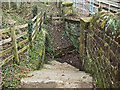
1
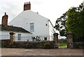
Blackwell Hall, Lowry Street
There is an Ordnance Survey benchmark Image on the inside face of the right hand gatepost
Image: © Roger Templeman
Taken: 28 Aug 2019
0.00 miles
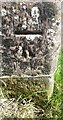
2
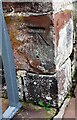
Benchmark on gatepost at entrance to Blackwell Hall
Ordnance Survey cut mark benchmark levelled at 45.160m above Newlyn Datum verified in 1972
Image: © Roger Templeman
Taken: 28 Aug 2019
0.00 miles
3
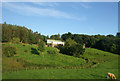
Blackwell Hall from riverside footpath
During a walk along Cumbria Way
Image: © Tony Vickers
Taken: 24 May 2008
0.03 miles
4
Pedestrian tunnel under Cumbrian Coast Railway (2)
Entrance on east side, downhill from Blackwell Hall Farm.
For view of interior, see Image .
Image: © Rose and Trev Clough
Taken: 3 Feb 2007
0.05 miles
5
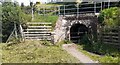
Bridge taking Cumbrian Coast Railway over footpath west of Blackwell Hall
There is an Ordnance Survey benchmark Image on the near end of the left hand bridge buttress
Image: © Luke Shaw
Taken: 21 Jul 2021
0.05 miles
6
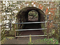
Pedestrian tunnel under Cumbrian Coast Railway (3)
Entrance at west side of tunnel, which is on a public footpath between Blackwell and Cummersdale.
The other end is shown here Image .
More correctly termed a railway underbridge - the bridge number 134 is painted on the arch.
Image: © Rose and Trev Clough
Taken: 3 Feb 2007
0.05 miles
7
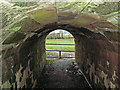
Pedestrian tunnel under Cumbrian Coast Railway (1)
On a public footpath between Blackwell and Cummersdale.
The path ahead leads to a footbridge, crossing the River Caldew to Cummersdale.
Image: © Rose and Trev Clough
Taken: 3 Feb 2007
0.05 miles
8
Benchmark on buttress of bridge taking footpath under railway west of Blackwell Hall
Ordnance Survey cut mark benchmark levelled at 24.700m above Newlyn Datum verified 1972
Image: © Roger Templeman
Taken: 21 Jul 2021
0.06 miles
9
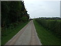
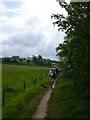
Lowry Street
A private road to Blackwell Hall - looking west.
Also used as a footpath to the River Caldew.
Image: © JThomas
Taken: 10 Oct 2015
0.07 miles