IMAGES TAKEN NEAR TO
Blackwell, CARLISLE, CA2 4SF
Introduction
This page details the photographs taken nearby to CA2 4SF by members of the Geograph project.
The Geograph project started in 2005 with the aim of publishing, organising and preserving representative images for every square kilometre of Great Britain, Ireland and the Isle of Man.

There are currently over 7.5m images from over14,400 individuals and you can help contribute to the project by visiting https://www.geograph.org.uk
Image Map
Images are licensed for reuse under creativecommons.org/licenses/by-sa/2.0
Notes
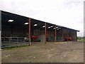
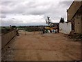
- Clicking on the map will re-center to the selected point.
- The higher the marker number, the further away the image location is from the centre of the postcode.
Image Listing (52 Images Found)
Images are licensed for reuse under creativecommons.org/licenses/by-sa/2.0
Image
Details
Distance
3
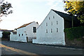
Whitewashed buildings, Blackwell Farm
In Lowry Street, Blackwell.
Image: © Rose and Trev Clough
Taken: 9 Aug 2013
0.04 miles
4
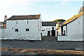
Blackwell Farm
Situated in Lowry Street.
Image: © Rose and Trev Clough
Taken: 9 Aug 2013
0.04 miles
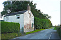
5
Ash Tree Cottage, Lowry Street
There is an Ordnance Survey benchmark Image on the road face of the house at its right hand corner
Image: © Luke Shaw
Taken: 28 Aug 2019
0.05 miles
6
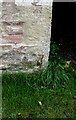
Benchmark on Ash Tree Cottage, south side Lowry Street
Ordnance Survey cut mark benchmark described on the Bench Mark Database at www.bench-marks.org.uk/bm103274
Image: © Luke Shaw
Taken: 28 Aug 2019
0.06 miles
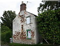
7
Ash Tree Cottage, Blackwell
Cottage in need of renovation, at the end of Lowry Street.
The private road ahead incorporates a public footpath to Cummersdale.
Information update : the cottage was still there in 2019 Image but has since been demolished.
Image: © Rose and Trev Clough
Taken: 9 Aug 2013
0.06 miles
8

End terrace house, Durdar Road, 2007
Since this photo was taken the house has been renovated and extended, and a parking area created in the front garden (Google Street View 2012 https://goo.gl/maps/tAn93FZVUcF2 ).
Image: © Rose and Trev Clough
Taken: 12 Aug 2007
0.06 miles
9
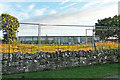
Disused accommodation block, Carlisle Racecourse (2013)
Accommodation for grooms adjacent to a horsebox and lorry park, which became redundant when new facilities were constructed.
Since this photo was taken, the building has been demolished.
Image: © Rose and Trev Clough
Taken: 9 Aug 2013
0.07 miles
10
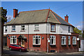
Former "White Ox", Blackwell, Carlisle - April 2017
Built 1904 to replace the T'Theekt Cott pub, the White Ox was unusual in having a Newfoundland slate roof. Taken into State ownership on 1 August 1916, it was returned to the private sector in 1973 (exact date and purchaser not yet found). Seems to have closed circa 2008 and is now a private dwelling.
For a photograph of the pub just before closure, see: Image] , and for one just after closure, see: http://www.geog.port.ac.uk/webmap/thelakes/html/lgaz/lk17761.htm
Image: © The Carlisle Kid
Taken: 12 Apr 2017
0.08 miles