IMAGES TAKEN NEAR TO
Durdar Road, CARLISLE, CA2 4SD
Introduction
This page details the photographs taken nearby to Durdar Road, CA2 4SD by members of the Geograph project.
The Geograph project started in 2005 with the aim of publishing, organising and preserving representative images for every square kilometre of Great Britain, Ireland and the Isle of Man.

There are currently over 7.5m images from over14,400 individuals and you can help contribute to the project by visiting https://www.geograph.org.uk
Image Map
Images are licensed for reuse under creativecommons.org/licenses/by-sa/2.0
Notes
- Clicking on the map will re-center to the selected point.
- The higher the marker number, the further away the image location is from the centre of the postcode.
Image Listing (69 Images Found)
Images are licensed for reuse under creativecommons.org/licenses/by-sa/2.0
Image
Details
Distance
1
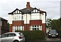
Nos. 29 and 31 Durdar Road
There is an Ordnance Survey benchmark Image on the side of the right hand house at its front corner
Image: © Luke Shaw
Taken: 28 Aug 2019
0.00 miles
2
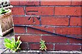
Benchmark on No. 31 Dundar Road
Ordnance Survey cut mark benchmark described on the Bench Mark Database at www.bench-marks.org.uk/bm103277
Image: © Luke Shaw
Taken: 28 Aug 2019
0.01 miles
5

Start of footpath to Upperby from Durdar Road (2014)
The path follows a farm track beside Blackwell Vale care home (left). A public footpath stopping up and diversion order is displayed on the gate.
Image: © Rose and Trev Clough
Taken: 25 Aug 2014
0.10 miles
7

End terrace house, Durdar Road, 2007
Since this photo was taken the house has been renovated and extended, and a parking area created in the front garden (Google Street View 2012 https://goo.gl/maps/tAn93FZVUcF2 ).
Image: © Rose and Trev Clough
Taken: 12 Aug 2007
0.11 miles
8

Field behind Blackwell Vale care home (2014)
Since the photo was taken, houses have been built on this end of the field (The Ridings https://www.storyhomes.co.uk/developments/the-ridings/ ). The developers intend to leave the far end of the field as an area of green space behind the Eden Valley Hospice.
Image: © Rose and Trev Clough
Taken: 25 Aug 2014
0.11 miles
9
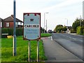
Carlisle welcome sign
Time to give this sign a makeover? On Blackwell Road, heading towards Currock.
Image: © Rose and Trev Clough
Taken: 24 Aug 2008
0.11 miles