IMAGES TAKEN NEAR TO
Manor Road, CARLISLE, CA2 4LJ
Introduction
This page details the photographs taken nearby to Manor Road, CA2 4LJ by members of the Geograph project.
The Geograph project started in 2005 with the aim of publishing, organising and preserving representative images for every square kilometre of Great Britain, Ireland and the Isle of Man.

There are currently over 7.5m images from over14,400 individuals and you can help contribute to the project by visiting https://www.geograph.org.uk
Image Map (Loading...)


Getting Data...Please wait
Leaflet Map data © OpenStreetMap
Images are licensed for reuse under creativecommons.org/licenses/by-sa/2.0
Notes
- Clicking on the map will re-center to the selected point.
- The higher the marker number, the further away the image location is from the centre of the postcode.
Image Listing (60 Images Found)
Images are licensed for reuse under creativecommons.org/licenses/by-sa/2.0
Image
Details
Distance
1
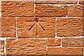
Benchmark on SE face of tower of St John the Baptist Church, Upperby
Ordnance Survey 1GL bolt benchmark shown on 1867 Map levelled at 148.5 feet above Liverpool Datum. The mark was measured as being 123cm above present ground level and 63cm from the tower south buttress
Image: © Luke Shaw
Taken: 15 Sep 2020
0.03 miles
3
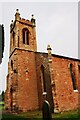
The tower of St John the Baptist Church, Upperby
There is an Ordnance Survey benchmark Image on the right hand face of the tower about 1.2m above ground level. The tower centre is a component of a OS intersected station trig point, http://trigpointing.uk/trig/11115
Image: © Roger Templeman
Taken: 15 Sep 2020
0.03 miles
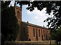
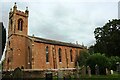
4
Church of St John the Baptist, Upperby
Built circa 1840, in early Gothic Revival style. A chapel extension was added in 1975.
The church of St John the Baptist is remarkably similar in structure to St John the Evangelist at Houghton, to the North of Carlisle - see Geograph photo https://www.geograph.org.uk/photo/5694555 . It is assumed that they were designed by the same architect.
Information for this description was found on the Diocese of Carlisle website https://www.carlislediocese.org.uk/church/carlisle-st-john-the-baptist.html .
Image: © Rose and Trev Clough
Taken: 7 Aug 2014
0.03 miles
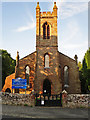
6
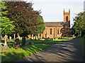
St John the Baptist Church and Upperby Cemetery
The church was built around 1840, and had a small graveyard. In 1881 a municipal cemetery was established here, which gradually expanded into adjacent fields over the years.
Image: © Rose and Trev Clough
Taken: 7 Aug 2014
0.04 miles
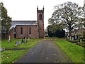
7
St John the Baptist Church, Upperby
Image: © Roger Templeman
Taken: 15 Sep 2020
0.04 miles
9
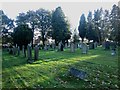
Upperby Cemetery, Carlisle (3)
An area of graves in the older part of Upperby Cemetery.
Image: © Graham Robson
Taken: 3 Nov 2013
0.05 miles
10
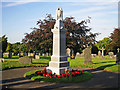
Upperby War Memorial
Located in Upperby Cemetery.
Inscription : In loving remembrance of the men of the parish of Saint Cuthbert Without who fell in the great war 1914-1918.
There are 24 names on the memorial. The men came from Upperby, which was just a village at the time, and surrounding hamlets including Blackwell, Brisco, Carleton and Woodbank.
In Upperby Cemetery there are 9 Commonwealth War Graves from World War I and 16 from World War II https://www.cwgc.org/find-a-cemetery/cemetery/2068320/Carlisle%20(Upperby)%20Cemetery .
Image: © Rose and Trev Clough
Taken: 7 Aug 2014
0.07 miles