IMAGES TAKEN NEAR TO
Upperby Road, CARLISLE, CA2 4JP
Introduction
This page details the photographs taken nearby to Upperby Road, CA2 4JP by members of the Geograph project.
The Geograph project started in 2005 with the aim of publishing, organising and preserving representative images for every square kilometre of Great Britain, Ireland and the Isle of Man.

There are currently over 7.5m images from over14,400 individuals and you can help contribute to the project by visiting https://www.geograph.org.uk
Image Map
Images are licensed for reuse under creativecommons.org/licenses/by-sa/2.0
Notes
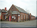
- Clicking on the map will re-center to the selected point.
- The higher the marker number, the further away the image location is from the centre of the postcode.
Image Listing (64 Images Found)
Images are licensed for reuse under creativecommons.org/licenses/by-sa/2.0
Image
Details
Distance
1
Bus stop on Upperby Road
Looking south east.
Image: © JThomas
Taken: 10 Oct 2015
0.02 miles
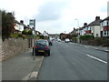
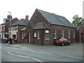
2
Upperby Methodist Church
A stone plaque above the door is inscribed 'PRIMITIVE METHODIST CHURCH.1901.' For further information, see http://www.myprimitivemethodists.org.uk/page_id__62.aspx?path=0p9p22p .
The church is on the corner of Upperby Road and Nursery Road (right). The latter leads to a side entrance at Upperby Primary School, but the road's name is not related to the school's infants - it refers to a plant nursery which used to occupy nearby land.
Image: © Rose and Trev Clough
Taken: 24 Jan 2013
0.07 miles
3
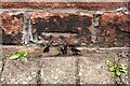
Benchmark on front of Upperby Methodist Church
Ordnance Survey cut mark benchmark levelled at 42.228m above Newlyn Datum verified in 1972
Image: © Luke Shaw
Taken: 1 Sep 2020
0.07 miles
4
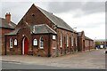
Upperby Methodist Church, Upperby Road at Nursery Road junction
There is an Ordnance Survey benchmark Image just above the pavement left of the main road porch door
Image: © Luke Shaw
Taken: 1 Sep 2020
0.07 miles
6
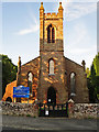
Church of St John the Baptist, Upperby
Built circa 1840, in early Gothic Revival style. A chapel extension was added in 1975.
The church of St John the Baptist is remarkably similar in structure to St John the Evangelist at Houghton, to the North of Carlisle - see Geograph photo https://www.geograph.org.uk/photo/5694555 . It is assumed that they were designed by the same architect.
Information for this description was found on the Diocese of Carlisle website https://www.carlislediocese.org.uk/church/carlisle-st-john-the-baptist.html .
Image: © Rose and Trev Clough
Taken: 7 Aug 2014
0.08 miles
7
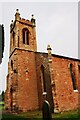
The tower of St John the Baptist Church, Upperby
There is an Ordnance Survey benchmark Image on the right hand face of the tower about 1.2m above ground level. The tower centre is a component of a OS intersected station trig point, http://trigpointing.uk/trig/11115
Image: © Roger Templeman
Taken: 15 Sep 2020
0.08 miles
8
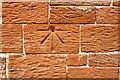
Benchmark on SE face of tower of St John the Baptist Church, Upperby
Ordnance Survey 1GL bolt benchmark shown on 1867 Map levelled at 148.5 feet above Liverpool Datum. The mark was measured as being 123cm above present ground level and 63cm from the tower south buttress
Image: © Luke Shaw
Taken: 15 Sep 2020
0.09 miles
9
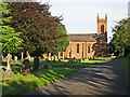
St John the Baptist Church and Upperby Cemetery
The church was built around 1840, and had a small graveyard. In 1881 a municipal cemetery was established here, which gradually expanded into adjacent fields over the years.
Image: © Rose and Trev Clough
Taken: 7 Aug 2014
0.09 miles
10
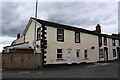
Nos.164 and 162 Upperby Road
Ordnance Survey records indicate that a benchmark levelled at 36.866m above Newlyn Datum was verified in 1972 on the left hand side of a shop No. 162 Upperby Road. Evidently that shop has been converted to two houses, with the left hand one renumbered to 164. See www.bench-marks.org.uk/bm103218
Image: © Luke Shaw
Taken: 1 Sep 2020
0.09 miles