IMAGES TAKEN NEAR TO
Harrison Street, CARLISLE, CA2 4ER
Introduction
This page details the photographs taken nearby to Harrison Street, CA2 4ER by members of the Geograph project.
The Geograph project started in 2005 with the aim of publishing, organising and preserving representative images for every square kilometre of Great Britain, Ireland and the Isle of Man.

There are currently over 7.5m images from over14,400 individuals and you can help contribute to the project by visiting https://www.geograph.org.uk
Image Map
Images are licensed for reuse under creativecommons.org/licenses/by-sa/2.0
Notes
- Clicking on the map will re-center to the selected point.
- The higher the marker number, the further away the image location is from the centre of the postcode.
Image Listing (67 Images Found)
Images are licensed for reuse under creativecommons.org/licenses/by-sa/2.0
Image
Details
Distance
1
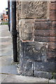
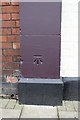
Benchmark on #2 Tithe Barn Street at junction with Salisbury Road
Ordnance Survey cut mark benchmark described on the Bench Mark Database at http://www.bench-marks.org.uk/bm38722
Image: © Roger Templeman
Taken: 26 Jun 2011
0.05 miles
2
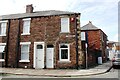
Houses at north end of Tithe Barn Street at Salisbury Road junction
There is an Ordnance Survey benchmark Image on the side of the right hand house (#2).
Image: © Luke Shaw
Taken: 1 Sep 2020
0.06 miles
4
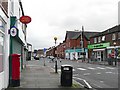
Currock Crossroads
Several local shops here, including a Post Office which survived the recent round of cuts. Sometimes referred to as Currock Cross or Five Road Ends.
Image: © Rose and Trev Clough
Taken: 7 Sep 2008
0.08 miles
5
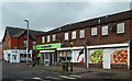
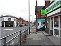
The Co-op At Currock Crossroads
A conveniently-located store on Carlisle's Blackwell Road, photographed in disappointingly poor light.
Image: © Mary and Angus Hogg
Taken: 23 Jan 2016
0.08 miles
6
Benchmark on The Currock pub
Ordnance Survey cut mark benchmark described on the Bench Mark Database at http://www.bench-marks.org.uk/bm38721
Image: © Roger Templeman
Taken: 26 Jun 2011
0.10 miles
7
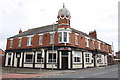
The Currock public house
At the junction of Robinson Avenue and Boundary Road
Image: © Roger Templeman
Taken: 26 Jun 2011
0.10 miles
8
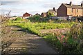
Site of demolished buildings, Regent Street
View through fence.
There used to be a NACRO training centre here. It was a modern construction - still standing in 2010 when Google Street View visited https://goo.gl/maps/HcfJ9YqW6r42 .
Image: © Rose and Trev Clough
Taken: 2 Oct 2016
0.10 miles
9
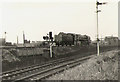
Last day of BR steam at Carlisle
Britannia class loco, 'Oliver Cromwell' steams back to Upperby shed, having hauled Britain's last ever BR steam-powered (standard-gauge) passenger train into Carlisle Citadel station.
Image: © Roger Cornfoot
Taken: Unknown
0.11 miles
10
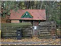
Former Public toilets, St Nicholas Bridges, Carlisle
These small former public toilets stand at the southern end of St Nicholas Bridges. The visible notice, attached to the locked gate and dating from November 2012 states that the city council has sought permission to demolish the building. This photo shows that though now unmaintained and out of use, the building is still standing in November 2013.
Image: © Graham Robson
Taken: 3 Nov 2013
0.12 miles