IMAGES TAKEN NEAR TO
Currock Road, CARLISLE, CA2 4AS
Introduction
This page details the photographs taken nearby to Currock Road, CA2 4AS by members of the Geograph project.
The Geograph project started in 2005 with the aim of publishing, organising and preserving representative images for every square kilometre of Great Britain, Ireland and the Isle of Man.

There are currently over 7.5m images from over14,400 individuals and you can help contribute to the project by visiting https://www.geograph.org.uk
Image Map
Images are licensed for reuse under creativecommons.org/licenses/by-sa/2.0
Notes
- Clicking on the map will re-center to the selected point.
- The higher the marker number, the further away the image location is from the centre of the postcode.
Image Listing (47 Images Found)
Images are licensed for reuse under creativecommons.org/licenses/by-sa/2.0
Image
Details
Distance
1
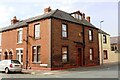
#47 Beaconsfield Street (Beech House) at Thirlmere Street junction
There is an Ordnance Survey benchmark Image on the corner of the house, right hand face, on its red skirt.
Image: © Roger Templeman
Taken: 15 Sep 2020
0.03 miles
2
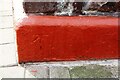
Benchmark on skirt of #47 Beaconsfield Street
Ordnance Survey cut mark benchmark levelled at 31.280m above Newlyn Datum verified in 1972
Image: © Roger Templeman
Taken: 15 Sep 2020
0.03 miles
3
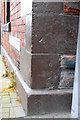
Benchmarks on #47 Beaconsfield Road
The upper Ordnance Survey cut mark benchmark is described on the Bench Mark Database at http://www.bench-marks.org.uk/bm38660 . The significance of the lower mark is unknown.
Image: © Roger Templeman
Taken: 26 Jun 2011
0.03 miles
4
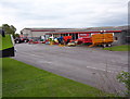
Agricultural Machinery Dealers
Rickerby Limited, Currock Rd, Carlisle
Image: © Michael Whitfield
Taken: 2 May 2004
0.04 miles
5
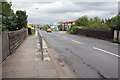
Currock Road: Railway Bridge at Petrol Station
Image: © Roger Templeman
Taken: 26 Jun 2011
0.04 miles
6
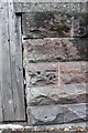
Benchmark on railway bridge on Currock Road
Ordnance Survey cut mark benchmark described on the Bench Mark Database at http://www.bench-marks.org.uk/bm38603
Image: © Roger Templeman
Taken: 26 Jun 2011
0.04 miles
7
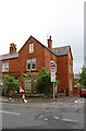
#57 Currock Road at Alton Street junction
There is an OS benchmark Image on the front of the house at its right hand corner behind a bush
Image: © Roger Templeman
Taken: 20 May 2017
0.08 miles
8
Benchmark hiding behind shrub on #57 Currock Road
Ordnance Survey cut mark benchmark described on the Bench Mark Database at http://www.bench-marks.org.uk/bm38663
Image: © Roger Templeman
Taken: 26 Jun 2011
0.08 miles
9
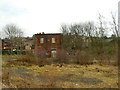
Site of the former Currock railway depot
See Image for the depot, which was demolished in 2016. The brick building may have been part of the railway site.
Image: © Stephen Craven
Taken: 15 Mar 2020
0.09 miles
10
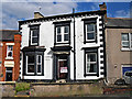
Currock Villa
A house dating from the mid-Victorian era. The Currock Villa Boys Club was established here in the 1950s, later on it became a mixed youth club but closed down around 2008.
The property has been sold since this photo was taken - it has planning permission for conversion to a residential children's home.
Image: © Rose and Trev Clough
Taken: 19 Aug 2013
0.12 miles