IMAGES TAKEN NEAR TO
MOOR ROW, CA24 3LF
Introduction
This page details the photographs taken nearby to CA24 3LF by members of the Geograph project.
The Geograph project started in 2005 with the aim of publishing, organising and preserving representative images for every square kilometre of Great Britain, Ireland and the Isle of Man.

There are currently over 7.5m images from over14,400 individuals and you can help contribute to the project by visiting https://www.geograph.org.uk
Image Map
Images are licensed for reuse under creativecommons.org/licenses/by-sa/2.0
Notes
- Clicking on the map will re-center to the selected point.
- The higher the marker number, the further away the image location is from the centre of the postcode.
Image Listing (8 Images Found)
Images are licensed for reuse under creativecommons.org/licenses/by-sa/2.0
Image
Details
Distance
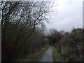
1
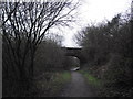
Railway Bridge
Bridge over the track bed of the Cleator and Furness Railway; now part of C2C; Sustrans route 72
Image: © Tim Glover
Taken: 31 Dec 2012
0.09 miles
2
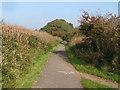
National Cycle Network route 72
In the foreground the Coast-to-Coast long-distance footpath leaves the cyclepath (which follows a disused railway) en route for Cleator (hence "C/C" painted on the tarmac).
Image: © Dave Dunford
Taken: 15 Oct 2006
0.15 miles
3
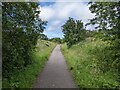
Cycle Route 72 on the old railway track
Image: © David Medcalf
Taken: 7 Jul 2022
0.16 miles
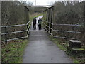
4
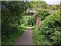
A substantial farm bridge over Cycle Route 72
Image: © David Medcalf
Taken: 7 Jul 2022
0.17 miles
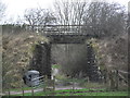
5
Railway Bridge
Bridge over the former trackbed of the Furness & Cleator Railway; now part of the C2C cycle way; route 62. The number 13 is painted on the parapet
Image: © Tim Glover
Taken: 31 Dec 2012
0.17 miles
6
Former railway bridge
Former overbridge of the Cleator and Furness Railway, the trackbed is now used as part of Cycle Route 72.
Image: © Tim Glover
Taken: 31 Dec 2012
0.17 miles
7
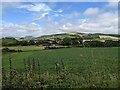
Looking east from the cycleway
Towards the hamlet of Cleator, with Dent hill in the distance.
Image: © David Medcalf
Taken: 7 Jul 2022
0.25 miles
8
Cycle Route 72
This bridge carries cycle route 72 over Blind Lane
Image: © Tim Glover
Taken: 31 Dec 2012
0.25 miles