IMAGES TAKEN NEAR TO
Ehen Hall, CLEATOR, CA23 3BZ
Introduction
This page details the photographs taken nearby to Ehen Hall, CA23 3BZ by members of the Geograph project.
The Geograph project started in 2005 with the aim of publishing, organising and preserving representative images for every square kilometre of Great Britain, Ireland and the Isle of Man.

There are currently over 7.5m images from over14,400 individuals and you can help contribute to the project by visiting https://www.geograph.org.uk
Image Map (Loading...)


Getting Data...Please wait
Leaflet Map data © OpenStreetMap
Images are licensed for reuse under creativecommons.org/licenses/by-sa/2.0
Notes
- Clicking on the map will re-center to the selected point.
- The higher the marker number, the further away the image location is from the centre of the postcode.
Image Listing (8 Images Found)
Images are licensed for reuse under creativecommons.org/licenses/by-sa/2.0
Image
Details
Distance
1
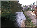
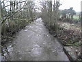
River Ehen, Cleator
Looking downstream from Blackhow Bridge on the Coast-to-Coast path.
Image: © Dave Dunford
Taken: 15 Oct 2006
0.09 miles
2
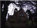
St Leonard's Church
St Leonard's Church, Cleator
Image: © Tim Glover
Taken: 31 Dec 2012
0.12 miles
3
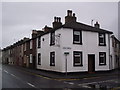
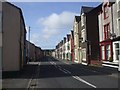
Kiln Brow, Cleator
Wainwright's Coast to Coast Path at the Junction of Main Street and Kiln Brow, Cleator
Image: © Tim Glover
Taken: 31 Dec 2012
0.13 miles
4
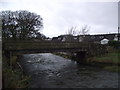
Blackhow Bridge
Wainwright's Coast to Coast Path uses Blackhow Bridge to cross the River Ehen at Cleator.
Image: © Tim Glover
Taken: 31 Dec 2012
0.14 miles
5
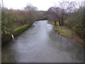
River Keekle
River Keekle looking downstream from Wainwright's Coast to Coast Path in Church Street, Cleator
Image: © Tim Glover
Taken: 31 Dec 2012
0.15 miles
7
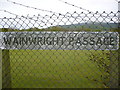
Sign on Wainwright's Coast to Coast Walk
A fitting name was given to this footpath near Cleator, which lies on the C2C route.
Image: © Phil Catterall
Taken: 19 May 2010
0.21 miles
8
The River Ehen
Looking upstream from the footbridge.
Image: © David Medcalf
Taken: 3 Dec 2015
0.23 miles