IMAGES TAKEN NEAR TO
Kinniside, CLEATOR, CA23 3AQ
Introduction
This page details the photographs taken nearby to CA23 3AQ by members of the Geograph project.
The Geograph project started in 2005 with the aim of publishing, organising and preserving representative images for every square kilometre of Great Britain, Ireland and the Isle of Man.

There are currently over 7.5m images from over14,400 individuals and you can help contribute to the project by visiting https://www.geograph.org.uk
Image Map
Images are licensed for reuse under creativecommons.org/licenses/by-sa/2.0
Notes
- Clicking on the map will re-center to the selected point.
- The higher the marker number, the further away the image location is from the centre of the postcode.
Image Listing (4 Images Found)
Images are licensed for reuse under creativecommons.org/licenses/by-sa/2.0
Image
Details
Distance
1
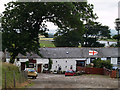
Low Cock How farm.
Farm and riding stables in Ennerdale, off the Calder bridge to Ennerdale bridge road.
Overnight stay during Coast to Coast walk.
Image: © ALAN SOUTHWORTH
Taken: 11 Jul 2006
0.01 miles
2
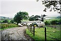
Low Cock How Farm
An overnight stay on the Coast to Coast route.
Image: © Peter S
Taken: 19 Aug 2007
0.03 miles