IMAGES TAKEN NEAR TO
CLEATOR, CA23 3AE
Introduction
This page details the photographs taken nearby to CA23 3AE by members of the Geograph project.
The Geograph project started in 2005 with the aim of publishing, organising and preserving representative images for every square kilometre of Great Britain, Ireland and the Isle of Man.

There are currently over 7.5m images from over14,400 individuals and you can help contribute to the project by visiting https://www.geograph.org.uk
Image Map
Images are licensed for reuse under creativecommons.org/licenses/by-sa/2.0
Notes
- Clicking on the map will re-center to the selected point.
- The higher the marker number, the further away the image location is from the centre of the postcode.
Image Listing (11 Images Found)
Images are licensed for reuse under creativecommons.org/licenses/by-sa/2.0
Image
Details
Distance
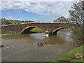
1
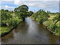
The River Ehen
Looking upstream from Wath Bridge.
Image: © David Medcalf
Taken: 7 Jul 2022
0.10 miles
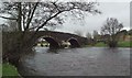
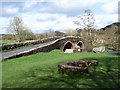
3
Wath bridge.
Straddling the river Ehen.
Image: © steven ruffles
Taken: 26 May 2016
0.10 miles
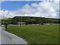
4
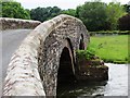
Crossing Wath Bridge
Parking nearby. A nice place to stop for a picnic.
Image: © Perry Dark
Taken: 3 Jul 2012
0.10 miles
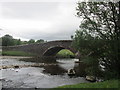
6
Wath Bridge
Carrying the Cleator Moor to Ennerdale Road across the River Ehen.
Image: © John Allan
Taken: 17 Apr 2018
0.11 miles

9
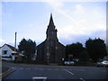
Cleator Moor Cockermouth Egremont Road Junction.
A very imposing place to build a church.
Image: © John Holmes
Taken: 11 Dec 2005
0.19 miles
10
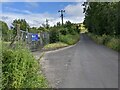
The gates to the water treatment plant
On Nannycatch Road.
Image: © David Medcalf
Taken: 7 Jul 2022
0.22 miles