IMAGES TAKEN NEAR TO
EGREMONT, CA22 2UF
Introduction
This page details the photographs taken nearby to CA22 2UF by members of the Geograph project.
The Geograph project started in 2005 with the aim of publishing, organising and preserving representative images for every square kilometre of Great Britain, Ireland and the Isle of Man.

There are currently over 7.5m images from over14,400 individuals and you can help contribute to the project by visiting https://www.geograph.org.uk
Image Map
Images are licensed for reuse under creativecommons.org/licenses/by-sa/2.0
Notes
- Clicking on the map will re-center to the selected point.
- The higher the marker number, the further away the image location is from the centre of the postcode.
Image Listing (3 Images Found)
Images are licensed for reuse under creativecommons.org/licenses/by-sa/2.0
Image
Details
Distance
1
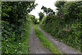
Grass Road towards Snellings Mire
A track leading off the B5345 towards Snellings Mire.
Image: © David P Howard
Taken: 7 Jul 2015
0.06 miles
2

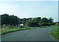
Fields south of B5345 near Middletown
The electricity lines go off to the right to the Sellafield nuclear plant about 5 kilometres away.
Image: © David P Howard
Taken: 7 Jul 2015
0.06 miles