IMAGES TAKEN NEAR TO
EGREMONT, CA22 2TY
Introduction
This page details the photographs taken nearby to CA22 2TY by members of the Geograph project.
The Geograph project started in 2005 with the aim of publishing, organising and preserving representative images for every square kilometre of Great Britain, Ireland and the Isle of Man.

There are currently over 7.5m images from over14,400 individuals and you can help contribute to the project by visiting https://www.geograph.org.uk
Image Map
Images are licensed for reuse under creativecommons.org/licenses/by-sa/2.0
Notes
- Clicking on the map will re-center to the selected point.
- The higher the marker number, the further away the image location is from the centre of the postcode.
Image Listing (3 Images Found)
Images are licensed for reuse under creativecommons.org/licenses/by-sa/2.0
Image
Details
Distance
1
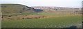
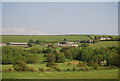
Pow Beck Valley
There is talk that a plan was made to put a canal from St Bees to Whitehaven along this valley because Whitehaven harbour could be difficult to sail into when the winds were in an unhelpful direction. I wonder what would be different if they had built this ship canal.View is from High Walton.
Image: © John Holmes
Taken: 28 Dec 2005
0.17 miles
2
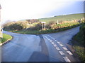
High Walton Road Junction.
You can just see High Walton on the edge of the picture that makes this a bad bend.
Image: © John Holmes
Taken: 11 Dec 2005
0.20 miles