IMAGES TAKEN NEAR TO
Bankend View, EGREMONT, CA22 2TH
Introduction
This page details the photographs taken nearby to Bankend View, CA22 2TH by members of the Geograph project.
The Geograph project started in 2005 with the aim of publishing, organising and preserving representative images for every square kilometre of Great Britain, Ireland and the Isle of Man.

There are currently over 7.5m images from over14,400 individuals and you can help contribute to the project by visiting https://www.geograph.org.uk
Image Map
Images are licensed for reuse under creativecommons.org/licenses/by-sa/2.0
Notes
- Clicking on the map will re-center to the selected point.
- The higher the marker number, the further away the image location is from the centre of the postcode.
Image Listing (8 Images Found)
Images are licensed for reuse under creativecommons.org/licenses/by-sa/2.0
Image
Details
Distance
1
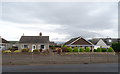
Bungalows on Springfield Road (A595), Bigrigg
Image: © JThomas
Taken: 16 Nov 2019
0.12 miles
2
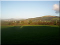
View from my office at Bigrigg
Taken on a bright wintry day it is the view from my office at Bigrigg across the fields to Woodend, Cleator Moor and in the distance, Ennerdale. What a view!
Image: © Angela Dean
Taken: 10 Oct 2006
0.13 miles

5
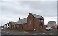
Former school on Springfield Road (A595), Bigrigg
Image: © JThomas
Taken: 16 Nov 2019
0.17 miles
6
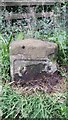
Old Milestone by the A595, south of Bigrigg
Metal plate attached to stone post by the A595, in parish of EGREMONT (COPELAND District), South East of Bigrigg, old railway bridge crossroads, on East side of road. Whitehaven plate stone, erected by the Whitehaven turnpike trust in the 19th century.
Inscription once read:-
: (TO WHITEHAVEN / 4 MILES) {from 1984 photo} : : (CALDER BRIDGE / 5½) {from old-maps} :
Grade II Listed. List Entry Number: 1137121
https://historicengland.org.uk/listing/the-list/list-entry/1137121
Milestone Society National ID: CU_WHCB04
Image: © Tim Pugh
Taken: 1 Sep 2016
0.21 miles
7
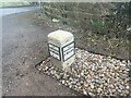
Old Milestone by A595, SouthEast of Bigrigg
The Milestone is located Old railway bridge crossroads on the East of the road. Parish of Egremont (Copeland District). Metal plate attached to stone post, Whitehaven plate stone design, erected by the Whitehaven turnpike trust in the 19th Century. An earlier photograph can be found here: https://www.geograph.org.uk/photo/5623129
Inscription reads:-
TO / CALDER BRIDGE / 5½ MILES :: TO WHITEHAVEN / 4 MILES
Grade II listed. List Entry Number: https://historicengland.org.uk/listing/the-list/list-entry/
Milestone Society National ID: CU_WHCB04
Image: © Karen Kelso
Taken: 12 Mar 2023
0.21 miles
8
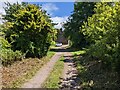
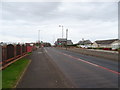
An unclassified road through the woods at Bigrigg
Image: © David Medcalf
Taken: 7 Jul 2022
0.22 miles