IMAGES TAKEN NEAR TO
Thorntrees Drive, EGREMONT, CA22 2SU
Introduction
This page details the photographs taken nearby to Thorntrees Drive, CA22 2SU by members of the Geograph project.
The Geograph project started in 2005 with the aim of publishing, organising and preserving representative images for every square kilometre of Great Britain, Ireland and the Isle of Man.

There are currently over 7.5m images from over14,400 individuals and you can help contribute to the project by visiting https://www.geograph.org.uk
Image Map
Images are licensed for reuse under creativecommons.org/licenses/by-sa/2.0
Notes
- Clicking on the map will re-center to the selected point.
- The higher the marker number, the further away the image location is from the centre of the postcode.
Image Listing (7 Images Found)
Images are licensed for reuse under creativecommons.org/licenses/by-sa/2.0
Image
Details
Distance
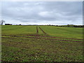
1
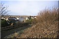
Thornhill.
They have used the old road shown here to form a footpath as the area now has a by pass.
Image: © John Holmes
Taken: 29 Dec 2005
0.05 miles
6
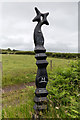
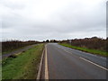
Millennium Milepost on National Cycle Route 72
This cast iron marker post by the side of the cycle route reads:
72, Sellafield 3 ½ , Egremont 2, Cleator Moor 5 ½
This is one of 1000 mileposts funded by The Royal Bank of Scotland to mark the millennium and the creation of the National Cycle Network.
Egremont to Sellafield cycleway was funded by English Partnerships, BNFL & Copeland Borough Council.
This route passes through private land. Please respect the land owner’s property and access.
Image: © David P Howard
Taken: 7 Jul 2015
0.17 miles
7
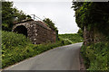
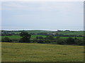
Old railway bridge piers
The B5345 passes between these stone built bridge piers, the trackbed and bridge having been removed.
The pier on the left has an interesting tunnel feature built through it. I have no idea what this was for.
Image: © David P Howard
Taken: 7 Jul 2015
0.20 miles