IMAGES TAKEN NEAR TO
Haile, EGREMONT, CA22 2PQ
Introduction
This page details the photographs taken nearby to CA22 2PQ by members of the Geograph project.
The Geograph project started in 2005 with the aim of publishing, organising and preserving representative images for every square kilometre of Great Britain, Ireland and the Isle of Man.

There are currently over 7.5m images from over14,400 individuals and you can help contribute to the project by visiting https://www.geograph.org.uk
Image Map
Images are licensed for reuse under creativecommons.org/licenses/by-sa/2.0
Notes
- Clicking on the map will re-center to the selected point.
- The higher the marker number, the further away the image location is from the centre of the postcode.
Image Listing (3 Images Found)
Images are licensed for reuse under creativecommons.org/licenses/by-sa/2.0
Image
Details
Distance
1
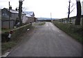
Whitehow Head.
BNG Sellafield just in sight on the horizon.
Image: © John Holmes
Taken: 29 Dec 2005
0.07 miles
2
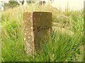
Boundary Stone
The second of the three Boundary Stones marking the parishes of St John Beckermet and Haile.
Image: © Peter Eckersley
Taken: 8 Jul 2006
0.18 miles
3
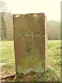
Boundary Stone
Of the three Boundary Stones indicated on the 1:25 000 OS map in NY0309 which mark the parishes of St John Beckermet and Haile, only two have been located. The one indicated at NY032092 has possibly been victim of road widening.
Image: © Peter Eckersley
Taken: 22 Apr 2006
0.24 miles