IMAGES TAKEN NEAR TO
Station Crescent, BECKERMET, CA21 2YU
Introduction
This page details the photographs taken nearby to Station Crescent, CA21 2YU by members of the Geograph project.
The Geograph project started in 2005 with the aim of publishing, organising and preserving representative images for every square kilometre of Great Britain, Ireland and the Isle of Man.

There are currently over 7.5m images from over14,400 individuals and you can help contribute to the project by visiting https://www.geograph.org.uk
Image Map
Images are licensed for reuse under creativecommons.org/licenses/by-sa/2.0
Notes
- Clicking on the map will re-center to the selected point.
- The higher the marker number, the further away the image location is from the centre of the postcode.
Image Listing (25 Images Found)
Images are licensed for reuse under creativecommons.org/licenses/by-sa/2.0
Image
Details
Distance
1
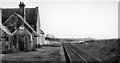
Beckermet Station (remains)
View southward, towards Sellafield; former Whitehaven, Cleator & Egremont (LNW & Furness) Joint Cleator Moor - Sellafield line, closed to passengers 16/6/47, to goods 2/3/64; possibly used for Workmen's trains to Sellafield Nuclear Plant later. It may be converted to a dwelling here.
Image: © Ben Brooksbank
Taken: 24 Sep 1961
0.04 miles
4
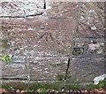
Ordnance Survey Cut Mark
This OS cut mark can be found on the building on the south side of Mill Lane. It marks a point 29.517m above mean sea level.
Image: © Adrian Dust
Taken: 7 Nov 2016
0.20 miles
5
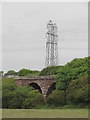
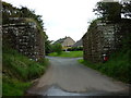
Kirk Beck Viaduct & modern pylons
Built by the Whitehaven, Cleator and Egremont Railway in 1857 it later joined with the Furness Railway to give access for coal & iron ore trains to reach ports like Barrow and Workington. The line closed after the last of the mines shut in the 1980's but it was not until 1993 that the tracks were lifted. Some of the line is now a rail trail.
Image: © Matthew Hatton
Taken: 5 Jun 2017
0.20 miles
6
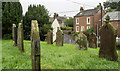
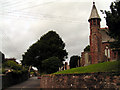
Gravestones at St. John's Church, Beckermet
The memorials seen are on the south side of the church; houses of the village lie beyond.
Image: © Trevor Littlewood
Taken: 4 Sep 2017
0.20 miles
8
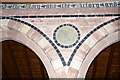
The Parish Church of St John, Beckermet, Wall detail
Image: © Alexander P Kapp
Taken: 18 Oct 2007
0.21 miles
9
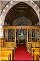
The Parish Church of St John, Beckermet, Screen
Image: © Alexander P Kapp
Taken: 18 Oct 2007
0.21 miles
10
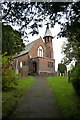
The Parish Church of St John, Beckermet
Image: © Alexander P Kapp
Taken: 18 Oct 2007
0.21 miles