IMAGES TAKEN NEAR TO
Sellafield, SEASCALE, CA20 1PG
Introduction
This page details the photographs taken nearby to CA20 1PG by members of the Geograph project.
The Geograph project started in 2005 with the aim of publishing, organising and preserving representative images for every square kilometre of Great Britain, Ireland and the Isle of Man.

There are currently over 7.5m images from over14,400 individuals and you can help contribute to the project by visiting https://www.geograph.org.uk
Image Map
Images are licensed for reuse under creativecommons.org/licenses/by-sa/2.0
Notes
- Clicking on the map will re-center to the selected point.
- The higher the marker number, the further away the image location is from the centre of the postcode.
Image Listing (6 Images Found)
Images are licensed for reuse under creativecommons.org/licenses/by-sa/2.0
Image
Details
Distance
1
Cloud over Sellafield (non radioactive)
Image: © Alexander P Kapp
Taken: 26 May 2006
0.03 miles
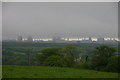
2
0717 Sellafield and Seascale
Looking westwards from above the Lake District to the Cumbrian coast.
Image: © M J Richardson
Taken: 21 Apr 2010
0.10 miles
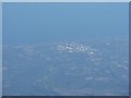
3
Sellafield nuclear reprocessing plant
A zoom shot from Great Worm Crag 18km away.
Image: © Karl and Ali
Taken: 2 Feb 2013
0.12 miles
4
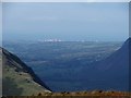
Sellafield from Hard Rigg.
The hill to the left is Illgill Head and to the right, Buckbarrow.
Image: © Steve Partridge
Taken: 23 Sep 2006
0.16 miles
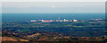
5
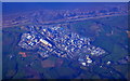
Sellafield nuclear site from the air
Former nuclear power station, now a nuclear processing plant. Formerly known as Windscale. Viewed from a Bristol bound flight from Glasgow.
Image: © Thomas Nugent
Taken: 11 Oct 2010
0.18 miles
6
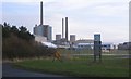
From the Mid Tarn Farm turnoff
The view of BNFL (British Nuclear Fuels Ltd) every time someone exits the farms road and looks right.
Image: © John Holmes
Taken: 31 Dec 2005
0.20 miles