IMAGES TAKEN NEAR TO
Gosforth, SEASCALE, CA20 1HT
Introduction
This page details the photographs taken nearby to CA20 1HT by members of the Geograph project.
The Geograph project started in 2005 with the aim of publishing, organising and preserving representative images for every square kilometre of Great Britain, Ireland and the Isle of Man.

There are currently over 7.5m images from over14,400 individuals and you can help contribute to the project by visiting https://www.geograph.org.uk
Image Map (Loading...)


Getting Data...Please wait
Leaflet Map data © OpenStreetMap
Images are licensed for reuse under creativecommons.org/licenses/by-sa/2.0
Notes
- Clicking on the map will re-center to the selected point.
- The higher the marker number, the further away the image location is from the centre of the postcode.
Image Listing (11 Images Found)
Images are licensed for reuse under creativecommons.org/licenses/by-sa/2.0
Image
Details
Distance
1
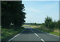
Bridge Petton.
This used to be on the edge of the main road now thankfully much straighter.
Image: © John Holmes
Taken: 21 Nov 2005
0.05 miles
5

Fell Views From Harecroft
Image taken from the rear garden of Harecroft Hall School, now sadly closed after over 80 years as a Private School. Looking towards Scafell
Image: © Mick Devine
Taken: 25 Oct 2007
0.11 miles