IMAGES TAKEN NEAR TO
The Loudons, CA20 1FE
Introduction
This page details the photographs taken nearby to The Loudons, CA20 1FE by members of the Geograph project.
The Geograph project started in 2005 with the aim of publishing, organising and preserving representative images for every square kilometre of Great Britain, Ireland and the Isle of Man.

There are currently over 7.5m images from over14,400 individuals and you can help contribute to the project by visiting https://www.geograph.org.uk
Image Map
Images are licensed for reuse under creativecommons.org/licenses/by-sa/2.0
Notes
- Clicking on the map will re-center to the selected point.
- The higher the marker number, the further away the image location is from the centre of the postcode.
Image Listing (27 Images Found)
Images are licensed for reuse under creativecommons.org/licenses/by-sa/2.0
Image
Details
Distance

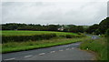
3

A595 near High Bridge Petton Farm
Towards Egremont.
Image: © JThomas
Taken: 16 Nov 2019
0.13 miles
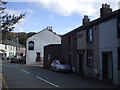
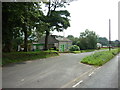
4
Gosforth
View towards the village from the B5344.
Image: © Peter Trimming
Taken: 7 Jul 2015
0.16 miles
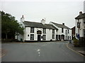
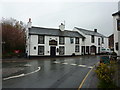
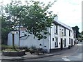
5
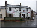
Gosforth
This is the road junction in the middle of the village. The pub is Ye Olde Lion & Lamb.
Image: © Humphrey Bolton
Taken: Unknown
0.16 miles