IMAGES TAKEN NEAR TO
Cross Lanes Industrial Estate, SEASCALE, CA20 1FB
Introduction
This page details the photographs taken nearby to Cross Lanes Industrial Estate, CA20 1FB by members of the Geograph project.
The Geograph project started in 2005 with the aim of publishing, organising and preserving representative images for every square kilometre of Great Britain, Ireland and the Isle of Man.

There are currently over 7.5m images from over14,400 individuals and you can help contribute to the project by visiting https://www.geograph.org.uk
Image Map
Images are licensed for reuse under creativecommons.org/licenses/by-sa/2.0
Notes
- Clicking on the map will re-center to the selected point.
- The higher the marker number, the further away the image location is from the centre of the postcode.
Image Listing (4 Images Found)
Images are licensed for reuse under creativecommons.org/licenses/by-sa/2.0
Image
Details
Distance
1
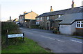
Houses on Cross Lanes at Gosforth Road junction
Image: © Roger Templeman
Taken: 29 Oct 2018
0.06 miles
4
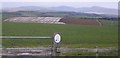
Lime Brown Field.
The use of lime to encourage grass to grow is staging a comeback after years of no application. The sign says "Defra - This land is managed under the countryside stewardship scheme" which may be part of the answer.
Image: © John Holmes
Taken: 15 Apr 2006
0.23 miles