IMAGES TAKEN NEAR TO
Wellington, SEASCALE, CA20 1ED
Introduction
This page details the photographs taken nearby to CA20 1ED by members of the Geograph project.
The Geograph project started in 2005 with the aim of publishing, organising and preserving representative images for every square kilometre of Great Britain, Ireland and the Isle of Man.

There are currently over 7.5m images from over14,400 individuals and you can help contribute to the project by visiting https://www.geograph.org.uk
Image Map
Images are licensed for reuse under creativecommons.org/licenses/by-sa/2.0
Notes
- Clicking on the map will re-center to the selected point.
- The higher the marker number, the further away the image location is from the centre of the postcode.
Image Listing (12 Images Found)
Images are licensed for reuse under creativecommons.org/licenses/by-sa/2.0
Image
Details
Distance
1
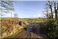
Farm track
Farm track and pasture fields near Bank House Farm
Image: © P Gaskell
Taken: Unknown
0.12 miles
3
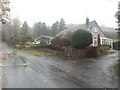
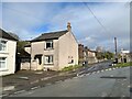
Village road in Wellington
A detached house on the north eastern side of one of the roads in the small village of Wellington.
Image: © Graham Robson
Taken: 3 Nov 2018
0.17 miles
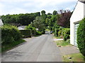
4
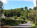
Road through Wellington
A minor, apparently unnamed, road passing through the small village of Wellington.
Image: © Graham Robson
Taken: 3 Nov 2018
0.18 miles
6
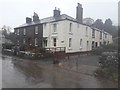
Houses in Wellington
A block of substantial stone built houses beside a minor road passing through Wellington.
Image: © Graham Robson
Taken: 3 Nov 2018
0.22 miles
7
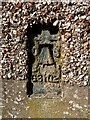
Benchmark, Wellington, Dalesend
Detail of the Ordnance Survey flush bracket benchmark number G3102 on the corner of Dalesend, a private house at Wellington. The benchmark, cement spattered and partly concealed by render marks a height of 58.4686 m above mean sea level (Ordnance Datum Newlyn) last levelled and verified in 1954 (photograph Image).
Image: © Adrian Taylor
Taken: 12 Mar 2022
0.22 miles
8
Wellington, Gosforth
There is an Ordnance Survey flush bracket benchmark visible on the corner of Dalesend; the house in the centre of the picture (photograph Image).
Image: © Adrian Taylor
Taken: 12 Mar 2022
0.22 miles
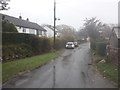
9
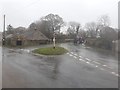
Road junction, Wellington
A road junction with a central patch of grass in the middle of Wellington. The tractor has just crossed Wellington Bridge.
Image: © Graham Robson
Taken: 3 Nov 2018
0.23 miles
10
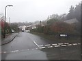
Walkmill Gardens, Wellington
A residential street off Wasdale Road in Wellington.
Image: © Graham Robson
Taken: 3 Nov 2018
0.23 miles