IMAGES TAKEN NEAR TO
Calderbridge, SEASCALE, CA20 1DZ
Introduction
This page details the photographs taken nearby to CA20 1DZ by members of the Geograph project.
The Geograph project started in 2005 with the aim of publishing, organising and preserving representative images for every square kilometre of Great Britain, Ireland and the Isle of Man.

There are currently over 7.5m images from over14,400 individuals and you can help contribute to the project by visiting https://www.geograph.org.uk
Image Map
Images are licensed for reuse under creativecommons.org/licenses/by-sa/2.0
Notes
- Clicking on the map will re-center to the selected point.
- The higher the marker number, the further away the image location is from the centre of the postcode.
Image Listing (5 Images Found)
Images are licensed for reuse under creativecommons.org/licenses/by-sa/2.0
Image
Details
Distance
1
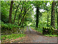
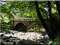
Access road for Monkwood Cottage
The road by which the cottage is reached runs alongside the River Calder which passes beneath Stakes Bridge just to the right, out of the image.
Image: © Trevor Littlewood
Taken: 4 Sep 2017
0.06 miles