IMAGES TAKEN NEAR TO
Church View, SEASCALE, CA20 1DL
Introduction
This page details the photographs taken nearby to Church View, CA20 1DL by members of the Geograph project.
The Geograph project started in 2005 with the aim of publishing, organising and preserving representative images for every square kilometre of Great Britain, Ireland and the Isle of Man.

There are currently over 7.5m images from over14,400 individuals and you can help contribute to the project by visiting https://www.geograph.org.uk
Image Map
Images are licensed for reuse under creativecommons.org/licenses/by-sa/2.0
Notes
- Clicking on the map will re-center to the selected point.
- The higher the marker number, the further away the image location is from the centre of the postcode.
Image Listing (27 Images Found)
Images are licensed for reuse under creativecommons.org/licenses/by-sa/2.0
Image
Details
Distance
1
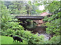
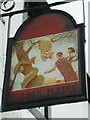
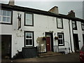
Road bridge over the River Calder at Calder Bridge
The picture was taken from the beer garden at the Stanley Arms Hotel
Image: © Perry Dark
Taken: 4 Jul 2012
0.01 miles
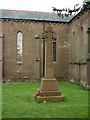
9
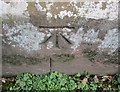
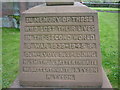
Ordnance Survey Cut Mark
This OS cut mark can be found on the NW face of St Bridget's Church. It marks a point 53.739m above mean sea level.
Image: © Adrian Dust
Taken: 7 Nov 2016
0.03 miles
10
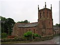
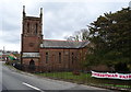
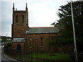
St Bridget's Church Calder Bridge
The church was built 1840 to 1842 out of local red sandstone.
Image: © Perry Dark
Taken: 4 Jul 2012
0.03 miles