IMAGES TAKEN NEAR TO
Ponsonby, SEASCALE, CA20 1BY
Introduction
This page details the photographs taken nearby to CA20 1BY by members of the Geograph project.
The Geograph project started in 2005 with the aim of publishing, organising and preserving representative images for every square kilometre of Great Britain, Ireland and the Isle of Man.

There are currently over 7.5m images from over14,400 individuals and you can help contribute to the project by visiting https://www.geograph.org.uk
Image Map
Images are licensed for reuse under creativecommons.org/licenses/by-sa/2.0
Notes
- Clicking on the map will re-center to the selected point.
- The higher the marker number, the further away the image location is from the centre of the postcode.
Image Listing (5 Images Found)
Images are licensed for reuse under creativecommons.org/licenses/by-sa/2.0
Image
Details
Distance
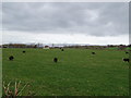
3
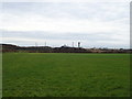
Grazing near Calder Bridge
Sellafield nuclear site on the horizon.
Image: © JThomas
Taken: 16 Nov 2019
0.11 miles
4
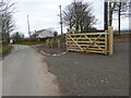
Where the bridleway to Ponsonby leaves the road
Image: © David Medcalf
Taken: 9 Mar 2014
0.13 miles
5
Sheep grazing near Newmill Farm
Off the A595.
Image: © JThomas
Taken: 16 Nov 2019
0.18 miles