IMAGES TAKEN NEAR TO
Ellerslie Terrace, SEASCALE, CA20 1BA
Introduction
This page details the photographs taken nearby to Ellerslie Terrace, CA20 1BA by members of the Geograph project.
The Geograph project started in 2005 with the aim of publishing, organising and preserving representative images for every square kilometre of Great Britain, Ireland and the Isle of Man.

There are currently over 7.5m images from over14,400 individuals and you can help contribute to the project by visiting https://www.geograph.org.uk
Image Map
Images are licensed for reuse under creativecommons.org/licenses/by-sa/2.0
Notes
- Clicking on the map will re-center to the selected point.
- The higher the marker number, the further away the image location is from the centre of the postcode.
Image Listing (35 Images Found)
Images are licensed for reuse under creativecommons.org/licenses/by-sa/2.0
Image
Details
Distance
1
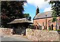
Parish Church, Gosforth
The well preserved viking cross is visible to the left of the wicket gate.
Image: © Nigel Monckton
Taken: 2 Sep 2005
0.12 miles
2
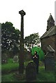
Viking cross in St Mary's churchyard, Gosforth
Image: © David Gearing
Taken: Unknown
0.14 miles
3
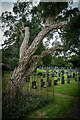
Cork Oak Tree, Gosforth
Sign Says :-
This Cork Oak was planted in approximately 1833 and is reputedly the most northerly growing in England
Image: © Brian Deegan
Taken: 17 Sep 2022
0.17 miles
5
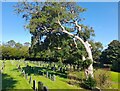
Cork Tree in St Mary's Churchyard Gosforth
The beautiful cork tree, growing in St Mary's Churchyard Gosforth since 1833.
Image: © Colin Kinnear
Taken: 13 Sep 2022
0.17 miles
6
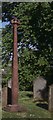
Viking cross, Gosforth churchyard
Image: © Christopher Hilton
Taken: 31 May 1991
0.17 miles
8
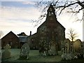
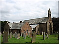
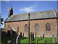
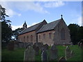
St Mary's Church, Gosforth
This is the westerly aspect of St Mary's Church, Gosforth, Cumbria.
This has been a Christian site since the 8th century. The oldest fabric in the present church dates from the 12th century. The church was reconstructed in 1789, but most of the fabric currently present is the result of a virtual rebuilding by C. J. Ferguson between 1896 and 1899.
St Mary's is constructed in stone with a slate roof. Its plan consists of a nave, a north aisle, a south porch, a chancel and north vestries. The 19th-century rebuilding is in Decorated style. At the west end is a corbelled-out bellcote. The gabled porch leads to the south door, to the right of which is a blocked Norman doorway, formerly on the north side of the church. There is a monument dated 1834 on the exterior of the north wall of the chancel
Image: © Rude Health
Taken: 2 Dec 2012
0.19 miles
9
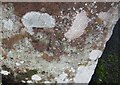
Ordnance Survey Cut Mark
This OS cut mark can be found on the east angle of St Mary's Church. It marks a point 58.412m above mean sea level.
Image: © Adrian Dust
Taken: 7 Nov 2016
0.19 miles