IMAGES TAKEN NEAR TO
Hallsenna, HOLMROOK, CA19 1YB
Introduction
This page details the photographs taken nearby to CA19 1YB by members of the Geograph project.
The Geograph project started in 2005 with the aim of publishing, organising and preserving representative images for every square kilometre of Great Britain, Ireland and the Isle of Man.

There are currently over 7.5m images from over14,400 individuals and you can help contribute to the project by visiting https://www.geograph.org.uk
Image Map
Images are licensed for reuse under creativecommons.org/licenses/by-sa/2.0
Notes
- Clicking on the map will re-center to the selected point.
- The higher the marker number, the further away the image location is from the centre of the postcode.
Image Listing (2 Images Found)
Images are licensed for reuse under creativecommons.org/licenses/by-sa/2.0
Image
Details
Distance
1
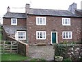
Hall Senna.
I was given some local guidance to find this one as there is some confusion with Hall Senna Farm just around the corner from here.
Image: © John Holmes
Taken: 21 Nov 2005
0.06 miles
2
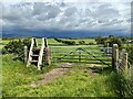
Stile and Gate near Crossleys
The stile is provided for a public footpath leading to the public bridleway at Crossleys, just visible in the right background.
There is a storm over the Lake District fells.
Image: © Adrian Taylor
Taken: 31 May 2022
0.25 miles