IMAGES TAKEN NEAR TO
Drigg, HOLMROOK, CA19 1XS
Introduction
This page details the photographs taken nearby to CA19 1XS by members of the Geograph project.
The Geograph project started in 2005 with the aim of publishing, organising and preserving representative images for every square kilometre of Great Britain, Ireland and the Isle of Man.

There are currently over 7.5m images from over14,400 individuals and you can help contribute to the project by visiting https://www.geograph.org.uk
Image Map
Images are licensed for reuse under creativecommons.org/licenses/by-sa/2.0
Notes
- Clicking on the map will re-center to the selected point.
- The higher the marker number, the further away the image location is from the centre of the postcode.
Image Listing (5 Images Found)
Images are licensed for reuse under creativecommons.org/licenses/by-sa/2.0
Image
Details
Distance
5
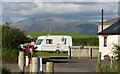
Reception area at Shepherds View
Self catering cottages and caravans and tent pitches
Image: © Perry Dark
Taken: 30 Jul 2012
0.24 miles