IMAGES TAKEN NEAR TO
Drigg, HOLMROOK, CA19 1XD
Introduction
This page details the photographs taken nearby to CA19 1XD by members of the Geograph project.
The Geograph project started in 2005 with the aim of publishing, organising and preserving representative images for every square kilometre of Great Britain, Ireland and the Isle of Man.

There are currently over 7.5m images from over14,400 individuals and you can help contribute to the project by visiting https://www.geograph.org.uk
Image Map
Images are licensed for reuse under creativecommons.org/licenses/by-sa/2.0
Notes
- Clicking on the map will re-center to the selected point.
- The higher the marker number, the further away the image location is from the centre of the postcode.
Image Listing (25 Images Found)
Images are licensed for reuse under creativecommons.org/licenses/by-sa/2.0
Image
Details
Distance
1
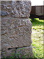
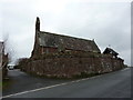
OS benchmark - Drigg, Hill Green Farm
An OS cutmark on the corner of the barn nearest to the road; originally levelled at 23.482m above Ordnance Datum Newlyn.
Image: © Richard Law
Taken: 2 Sep 2015
0.05 miles
2
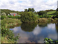
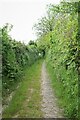
River Irt, Holmrook
The building in the background is the village Reading Room.
Image: © Nigel Monckton
Taken: 1 Sep 2005
0.13 miles
4
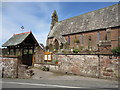
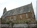
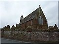
St Peter's Church
The original medieval church was rebuilt in its entirety in 1850. The stained glass windows, including an unusual curved triangular vestry window, were renovated in 2010.
Source: Drigg village hall information board.
Image: © Perry Dark
Taken: 3 Aug 2012
0.19 miles
9
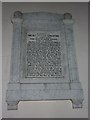
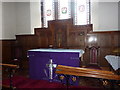
St Peter's Church, Drigg, Memorial
Image: © Alexander P Kapp
Taken: 13 Apr 2011
0.21 miles