IMAGES TAKEN NEAR TO
Santon Bridge, HOLMROOK, CA19 1UY
Introduction
This page details the photographs taken nearby to CA19 1UY by members of the Geograph project.
The Geograph project started in 2005 with the aim of publishing, organising and preserving representative images for every square kilometre of Great Britain, Ireland and the Isle of Man.

There are currently over 7.5m images from over14,400 individuals and you can help contribute to the project by visiting https://www.geograph.org.uk
Image Map
Images are licensed for reuse under creativecommons.org/licenses/by-sa/2.0
Notes
- Clicking on the map will re-center to the selected point.
- The higher the marker number, the further away the image location is from the centre of the postcode.
Image Listing (67 Images Found)
Images are licensed for reuse under creativecommons.org/licenses/by-sa/2.0
Image
Details
Distance
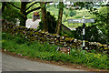
1
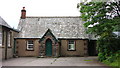
Santon Bridge School
Built in 1864; now forms part of the village hall.
Image: © David Rogers
Taken: 12 Jul 2010
0.00 miles
2
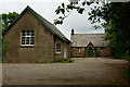
Santon Bridge Village Hall, Cumbria
Located beside the road junction, at the eastern edge of the village.
Image: © Peter Trimming
Taken: 16 Jun 2013
0.01 miles
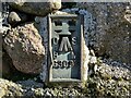
4
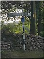
Old Direction Sign - Signpost near Santon Bridge
Ball finial - 3 arms; by the UC road, in parish of Irton with Santon (Copeland District), T junction at Santon Bridge.
To be surveyed
Milestone Society National ID: CU_NY1101A.
Image: © Milestone Society
Taken: Unknown
0.04 miles
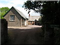
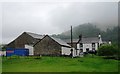
5
Santon Bridge, Cumbria
Tea Room to the left, Inn to the right.
Image: © Peter Trimming
Taken: 16 Jun 2013
0.04 miles
7
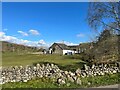
Broken wall near Bridge End Farm
Damaged by winter storms, the roadside wall awaits repair.
Image: © Adrian Taylor
Taken: 5 Mar 2022
0.05 miles
8
Benchmark, Santon Bridge, Bridge End Farm
Detail of the Ordnance Survey flush bracket benchmark number G3097 on the corner of a farm building at Bridge End Farm. The benchmark marks a height of 29.5775m above mean sea level (Ordnance Datum Newlyn) last levelled and verified in 1954 (location photograph Image).
Image: © Adrian Taylor
Taken: 5 Mar 2022
0.06 miles
9
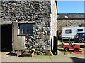
Bridge End Farm
Built from granite, this building at Bridge End farm has an Ordnance Survey flush bracket benchmark set into the stonework just above the bottom quoin (photograph Image).
Image: © Adrian Taylor
Taken: 5 Mar 2022
0.06 miles
10
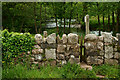
Footpath at Santon Bridge, Cumbria
View towards the River Irt. Note the narrow entrance, via the wall, to ensure that animals cannot escape onto the road.
Image: © Peter Trimming
Taken: 16 Jun 2013
0.09 miles