IMAGES TAKEN NEAR TO
Irton, HOLMROOK, CA19 1TB
Introduction
This page details the photographs taken nearby to CA19 1TB by members of the Geograph project.
The Geograph project started in 2005 with the aim of publishing, organising and preserving representative images for every square kilometre of Great Britain, Ireland and the Isle of Man.

There are currently over 7.5m images from over14,400 individuals and you can help contribute to the project by visiting https://www.geograph.org.uk
Image Map
Images are licensed for reuse under creativecommons.org/licenses/by-sa/2.0
Notes
- Clicking on the map will re-center to the selected point.
- The higher the marker number, the further away the image location is from the centre of the postcode.
Image Listing (12 Images Found)
Images are licensed for reuse under creativecommons.org/licenses/by-sa/2.0
Image
Details
Distance
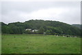
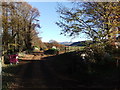
2
Mount Pleasant, Cumbria
Seen from the road to Eskdale Green.
Image: © Peter Trimming
Taken: 18 Mar 2015
0.02 miles
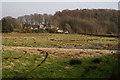
5
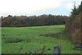
Grass field beside Calfclose Wood
There didn't appear to be any calves (or other cattle) in the close.
Image: © Graham Robson
Taken: 1 Nov 2018
0.08 miles
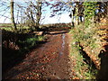
7
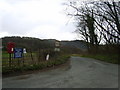
Road to Eskdale Green
Road junction near Irton Hall
Image: © Michael Graham
Taken: 28 Mar 2009
0.13 miles
8
Bridleway to Kitchen Ground
It's also their only access.
Image: © Bob Jenkins
Taken: 4 Feb 2006
0.14 miles
9
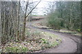
S-bend
Public footpath follows muddy farmtrack over a tiny beck.
Image: © Bob Jenkins
Taken: 4 Feb 2006
0.15 miles
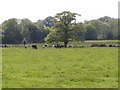
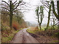
10
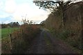
Track west of Cragg Farm
The track passing a field to the west of Cragg Farm is also a public footpath. The track provides access to a few local farms.
Image: © Graham Robson
Taken: 1 Nov 2018
0.21 miles