IMAGES TAKEN NEAR TO
South Road, KIRKBY STEPHEN, CA17 4SY
Introduction
This page details the photographs taken nearby to South Road, CA17 4SY by members of the Geograph project.
The Geograph project started in 2005 with the aim of publishing, organising and preserving representative images for every square kilometre of Great Britain, Ireland and the Isle of Man.

There are currently over 7.5m images from over14,400 individuals and you can help contribute to the project by visiting https://www.geograph.org.uk
Image Map (Loading...)


Getting Data...Please wait
Leaflet Map data © OpenStreetMap
Images are licensed for reuse under creativecommons.org/licenses/by-sa/2.0
Notes
- Clicking on the map will re-center to the selected point.
- The higher the marker number, the further away the image location is from the centre of the postcode.
Image Listing (91 Images Found)
Images are licensed for reuse under creativecommons.org/licenses/by-sa/2.0
Image
Details
Distance
2
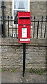
Elizabeth II postbox on South Road, Kirkby Stephen
Postbox No. CA17 112.
See Image] for context.
Image: © JThomas
Taken: 30 Apr 2021
0.01 miles
3
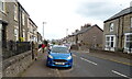
South Road (A685), Kirkby Stephen
Showing position of Postbox No. CA17 112.
See Image] for postbox.
Image: © JThomas
Taken: 30 Apr 2021
0.01 miles
4
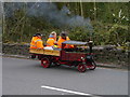
Miniature Steam Wagon In Kirkby Stephen
A 4.5" Foden miniature steam wagon travelling south through Kirkby Stephen during the 2017 rally.
Image: © James T M Towill
Taken: 15 Apr 2017
0.02 miles
5
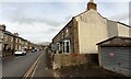
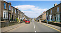
View NE along South Road (A685)
There is an Ordnance Survey benchmark Image on the near face of the nearest house at its front corner
Image: © Roger Templeman
Taken: 25 Oct 2022
0.02 miles
6
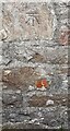
Benchmark on SW face of #45 South Street
Ordnance Survey cut mark benchmark levelled at 191.253m above Newlyn Datum verified 1970
Image: © Roger Templeman
Taken: 25 Oct 2022
0.03 miles
7
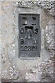
Benchmark on Sunsoar Paragliding Centre
Ordnance Survey flush bracket (serial number G2361) benchmark described on the Bench Mark Database at http://www.bench-marks.org.uk/bm765
Image: © Roger Templeman
Taken: 3 Sep 2014
0.06 miles
8
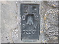
Ordnance Survey Flush Bracket G2361
This bracket can be found on the wall of the building that is currently used by the Paragliding Centre.
For more detail see : http://www.bench-marks.org.uk/bm765
Image: © Peter Wood
Taken: 4 Jun 2012
0.07 miles
9
Potter Brothers garage, Rowgate
A service station in the old sense: motor servicing as well as petrol sales.
Image: © Stephen Craven
Taken: 22 Jun 2009
0.07 miles
10
Warehouse occupied by Sunsoar, Paragliding
There is an OS flush bracket benchmark Image on the front of the building at its left hand corner
Image: © Roger Templeman
Taken: 3 Sep 2014
0.07 miles