IMAGES TAKEN NEAR TO
Mellwood, KIRKBY STEPHEN, CA17 4SD
Introduction
This page details the photographs taken nearby to Mellwood, CA17 4SD by members of the Geograph project.
The Geograph project started in 2005 with the aim of publishing, organising and preserving representative images for every square kilometre of Great Britain, Ireland and the Isle of Man.

There are currently over 7.5m images from over14,400 individuals and you can help contribute to the project by visiting https://www.geograph.org.uk
Image Map
Images are licensed for reuse under creativecommons.org/licenses/by-sa/2.0
Notes
- Clicking on the map will re-center to the selected point.
- The higher the marker number, the further away the image location is from the centre of the postcode.
Image Listing (45 Images Found)
Images are licensed for reuse under creativecommons.org/licenses/by-sa/2.0
Image
Details
Distance
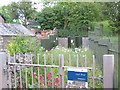
1
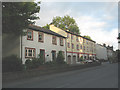
Old and new houses, South Road, Kirkby Stephen
The newer houses in the centre of the shot have been tastefully built adjacent to, and complementing the style of, a pair of older houses in the foreground.
Image: © Stephen Craven
Taken: 22 Jun 2009
0.00 miles
2
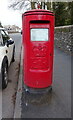
Elizabeth II postbox on South Road, Kirkby Stephen
Postbox No. CA17 113.
Image: © JThomas
Taken: 29 Apr 2021
0.01 miles
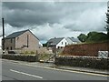
5
South Road substation
A United Utilites facility, on the southern edge of Kirkby Stephen town.
Image: © Stephen Craven
Taken: 22 Jun 2009
0.05 miles
6
Maple Terrace and Elderberry Drive
New housing development of the site of a derelict house Image On the east side of South Road, Kirkby Stephen.
Image: © Christine Johnstone
Taken: 26 Jun 2023
0.07 miles
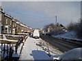
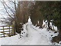
7
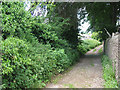
Croglam Lane, Kirkby Stephen
A 'back lane' that runs parallel to South Road, and is a public footpath.
Image: © Stephen Craven
Taken: 24 Jun 2009
0.07 miles
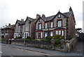
10
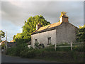
Derelict house at the top of High Street
This derelict, rural-looking property is on the east side of the main road out of Kirkby Stephen at the point where the road name changes from High Street to South Road. Perhaps it was once the last house in town.
Image: © Stephen Craven
Taken: 22 Jun 2009
0.10 miles