IMAGES TAKEN NEAR TO
Westbrook Fields, KIRKBY STEPHEN, CA17 4SB
Introduction
This page details the photographs taken nearby to Westbrook Fields, CA17 4SB by members of the Geograph project.
The Geograph project started in 2005 with the aim of publishing, organising and preserving representative images for every square kilometre of Great Britain, Ireland and the Isle of Man.

There are currently over 7.5m images from over14,400 individuals and you can help contribute to the project by visiting https://www.geograph.org.uk
Image Map (Loading...)


Getting Data...Please wait
Leaflet Map data © OpenStreetMap
Images are licensed for reuse under creativecommons.org/licenses/by-sa/2.0
Notes
- Clicking on the map will re-center to the selected point.
- The higher the marker number, the further away the image location is from the centre of the postcode.
Image Listing (37 Images Found)
Images are licensed for reuse under creativecommons.org/licenses/by-sa/2.0
Image
Details
Distance
4
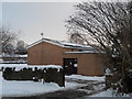
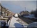
Telephone Exchange, Kirkby Stephen
Situated in Westgarth Avenue near Faraday Road, this neat looking TE has the code LCKST. It provides telephone and broadband services to 1,427 residential and 135 non-residential premises in Kirkby Stephen plus Crosby Garrett, Hartley, Kaber, Nateby, Outhgill, Rookby, Smardale, Soulby, Waitby and Winton nearby. It has (017683) 71xxx, 72xxx numbers, the (017683) referring to the Appleby group of four TEs, and its postcode is CA17 4TD.
Image: © David Hillas
Taken: 14 Jul 2010
0.08 miles
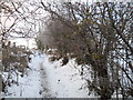
6
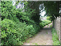
Croglam Lane, Kirkby Stephen
A 'back lane' that runs parallel to South Road, and is a public footpath.
Image: © Stephen Craven
Taken: 24 Jun 2009
0.09 miles
7
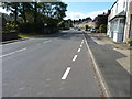
Main Street, Kirkby Stephen
A quiet day on the A685 in Kirkby Stephen.
Image: © James Allan
Taken: 11 Sep 2019
0.09 miles
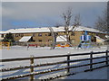
8
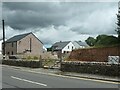
Maple Terrace and Elderberry Drive
New housing development of the site of a derelict house Image On the east side of South Road, Kirkby Stephen.
Image: © Christine Johnstone
Taken: 26 Jun 2023
0.09 miles

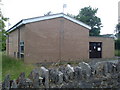
10
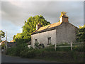
Derelict house at the top of High Street
This derelict, rural-looking property is on the east side of the main road out of Kirkby Stephen at the point where the road name changes from High Street to South Road. Perhaps it was once the last house in town.
Image: © Stephen Craven
Taken: 22 Jun 2009
0.10 miles