IMAGES TAKEN NEAR TO
Hartley Road, KIRKBY STEPHEN, CA17 4RU
Introduction
This page details the photographs taken nearby to Hartley Road, CA17 4RU by members of the Geograph project.
The Geograph project started in 2005 with the aim of publishing, organising and preserving representative images for every square kilometre of Great Britain, Ireland and the Isle of Man.

There are currently over 7.5m images from over14,400 individuals and you can help contribute to the project by visiting https://www.geograph.org.uk
Image Map
Images are licensed for reuse under creativecommons.org/licenses/by-sa/2.0
Notes
- Clicking on the map will re-center to the selected point.
- The higher the marker number, the further away the image location is from the centre of the postcode.
Image Listing (297 Images Found)
Images are licensed for reuse under creativecommons.org/licenses/by-sa/2.0
Image
Details
Distance
3
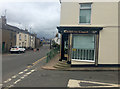
The Coast to Coast chip shop
On the A685 North Road in Kirkby Stephen. It takes its name from Wainwright's Coast to Coast Path, which runs through the town.
Image: © John Allan
Taken: 23 Apr 2018
0.05 miles
4

Gulf service station on North Road (A685), Kirkby Stephen
Image: © JThomas
Taken: 29 Apr 2021
0.06 miles
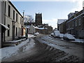
5
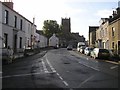
North Road, Kirkby Stephen
Heading south towards Market Street
Image: © Kenneth Allen
Taken: 8 Oct 2009
0.07 miles
6
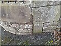
Ordnance Survey Cut Mark
This OS cut mark can be found on the NE angle of the Masonic Hall. It marks a point 169.395m above mean sea level.
Image: © Adrian Dust
Taken: 28 Oct 2023
0.07 miles
7
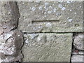
Ordnance Survey Cut Mark
This mark can be found on the wall of the Masonic Hall.
For more detail see : http://www.bench-marks.org.uk/bm24293
Image: © Peter Wood
Taken: 4 Jun 2012
0.08 miles
9
Benchmark on Masonic Hall
Ordnance Survey cut mark benchmark described on the Bench Mark Database at www.bench-marks.org.uk/bm24293
Image: © Roger Templeman
Taken: 26 Jul 2017
0.08 miles
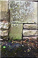
10
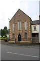
Masonic Hall, North Road
There is an Ordnance Survey benchmark Image on the right hand side of the hall at its front corner
Image: © Roger Templeman
Taken: 26 Jul 2017
0.08 miles