IMAGES TAKEN NEAR TO
Hobson Lane, KIRKBY STEPHEN, CA17 4RN
Introduction
This page details the photographs taken nearby to Hobson Lane, CA17 4RN by members of the Geograph project.
The Geograph project started in 2005 with the aim of publishing, organising and preserving representative images for every square kilometre of Great Britain, Ireland and the Isle of Man.

There are currently over 7.5m images from over14,400 individuals and you can help contribute to the project by visiting https://www.geograph.org.uk
Image Map
Images are licensed for reuse under creativecommons.org/licenses/by-sa/2.0
Notes
- Clicking on the map will re-center to the selected point.
- The higher the marker number, the further away the image location is from the centre of the postcode.
Image Listing (100 Images Found)
Images are licensed for reuse under creativecommons.org/licenses/by-sa/2.0
Image
Details
Distance
1
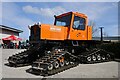
Tucker Sno-Cat 1700
'K18 British Antarctic Survey' can be noted on the cab doors, but no other information was available about this remarkable vehicle, pictured in Kirkby Stephen Business Park.
Image: © James T M Towill
Taken: 31 Mar 2024
0.03 miles
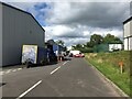
4
Lorry Park?
Classic heavy vehicles take over the Co-Op car park as part of the annual Easter weekend transport festival at Kirkby Stephen.
Image: © John H Darch
Taken: 16 Apr 2006
0.07 miles
6
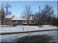
Kirkby Stephen Business Park
Not yet finished, but built on a greenfield site on the edge of town.
Image: © Bill Boaden
Taken: 24 Jul 2010
0.08 miles
7
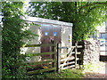
Christian Head water pumping station
On the corner of Christian Head and Bloody Bones Lane Image
Image: © Stephen Craven
Taken: 23 Jun 2009
0.10 miles
8
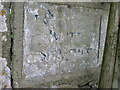
Old Guide Stone, Christian Head, Kirkby Stephen
The guide stone is located at the junction of roads to Soulby and Smardale, set in the wall on the west side of the road. Parish of Kirkby Stephen (Eden district). Erected in the 19th century.
Inscription reads:-
{hand to left} WAITBY / SMARDALE | {hand to right} SOULBY
Milestone Society National ID: WE_KSAP00
Image: © Christine Minto
Taken: 22 Aug 2009
0.10 miles
9
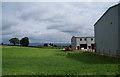
Road into Kirkby Stephen from Sandwath
There is an Ordnance Survey benchmark on the roadside wall described on the Bench Mark Database at www.bench-marks.org.uk/bm27845
Image: © Roger Templeman
Taken: 1 Jul 2021
0.10 miles
10

Co-op in Kirkby Stephen
A view of the entrance of the large Co-op in Kirkby Stephen, accessed from the A685 and then Redmayne Road.
Image: © John P Reeves
Taken: 28 Aug 2020
0.10 miles