IMAGES TAKEN NEAR TO
Ravenstonedale, KIRKBY STEPHEN, CA17 4LW
Introduction
This page details the photographs taken nearby to CA17 4LW by members of the Geograph project.
The Geograph project started in 2005 with the aim of publishing, organising and preserving representative images for every square kilometre of Great Britain, Ireland and the Isle of Man.

There are currently over 7.5m images from over14,400 individuals and you can help contribute to the project by visiting https://www.geograph.org.uk
Image Map
Images are licensed for reuse under creativecommons.org/licenses/by-sa/2.0
Notes
- Clicking on the map will re-center to the selected point.
- The higher the marker number, the further away the image location is from the centre of the postcode.
Image Listing (91 Images Found)
Images are licensed for reuse under creativecommons.org/licenses/by-sa/2.0
Image
Details
Distance
1
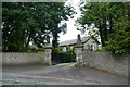
Coldbeck gateway
The western extension of Ravenstonedale, at Coldbeck, seems to be comprised of secluded properties behind Victorian plantings of Pacific Northwest trees. This gateway leads to various, now separate, addresses which would once have formed part of an estate either side of what was the main road through Ravenstonedale before it was bypassed.
Image: © Andy Waddington
Taken: 5 Sep 2020
0.02 miles
2
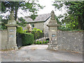
Converted property at Coldbeck
There are three different addresses given on slate plaques either side of the imposing gateway, so presumably one large property has been divided into separate apartments.
Image: © Stephen Craven
Taken: 23 Jun 2009
0.03 miles
3
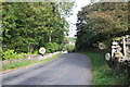
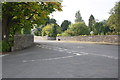
Road into Ravenstonedale from Coldbeck
Image: © Roger Templeman
Taken: 19 Sep 2014
0.04 miles
4
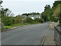
Bus stop in Ravenstonedale
The village is served by an infrequent service from Kirkby Stephen to Kendal.
Image: © Stephen Craven
Taken: 15 Sep 2020
0.05 miles
5
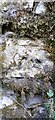
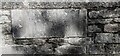
Benchmark on stone in wall on south side of Kirkby Stephen Road at a wall junction
Ordnance Survey cut mark benchmark levelled at 250.267m above Newlyn Datum in 1969
Image: © Roger Templeman
Taken: 15 Sep 2022
0.06 miles
7
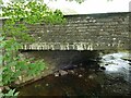
Coldbeck Bridge, Ravenstonedale
The bridge carries the main road through the village, once the A685, before the village was bypassed in the 1960s. The bridge was presumably rebuilt at the same time, as it carries a datestone of 1967. It consists of a concrete deck and stone parapets.
Image: © Stephen Craven
Taken: 15 Sep 2020
0.06 miles
8
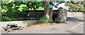
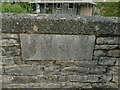
South parapet of Coldbeck Bridge and wall on SE side of river opposite Kings Head Hotel
Ordnance Survey documents indicate that a rivet benchmark was levelled at 242.630m above Newlyn Datum in 1969 on the near face of the bridge buttress: it appears to have been lost
Image: © Roger Templeman
Taken: 15 Sep 2022
0.06 miles
9
Dated Westmorland County Council name plaque on Coldbeck Bridge
The plaque has Milestone Society National ID: WE_RAVE02br
Image: © Roger Templeman
Taken: 15 Sep 2022
0.07 miles
10
Coldbeck Bridge, Ravenstonedale datestone
The bridge carries the main road through the village, once the A685, before the village was bypassed in the 1960s. The bridge was presumably rebuilt at the same time, as it carries a datestone of 1967. WCC would be Westmorland County Council.
Image: © Stephen Craven
Taken: 15 Sep 2020
0.07 miles