IMAGES TAKEN NEAR TO
Greenside Lane, KIRKBY STEPHEN, CA17 4LU
Introduction
This page details the photographs taken nearby to Greenside Lane, CA17 4LU by members of the Geograph project.
The Geograph project started in 2005 with the aim of publishing, organising and preserving representative images for every square kilometre of Great Britain, Ireland and the Isle of Man.

There are currently over 7.5m images from over14,400 individuals and you can help contribute to the project by visiting https://www.geograph.org.uk
Image Map
Images are licensed for reuse under creativecommons.org/licenses/by-sa/2.0
Notes
- Clicking on the map will re-center to the selected point.
- The higher the marker number, the further away the image location is from the centre of the postcode.
Image Listing (18 Images Found)
Images are licensed for reuse under creativecommons.org/licenses/by-sa/2.0
Image
Details
Distance
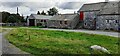
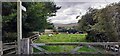
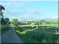
1
Farm buildings at Greenside Farm on NW side of Greenside Lane
Image: © Luke Shaw
Taken: 15 Sep 2022
0.02 miles
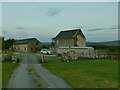
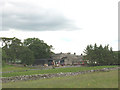
2
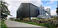
Greenside Farm, Ravenstonedale
Home to V-Mac who manufacture agricultural silos and other equipment.
Image: © Stephen Craven
Taken: 14 Sep 2020
0.03 miles
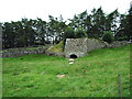
3
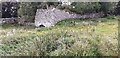
Disused lime kiln on SE side of Greenside Lane opposite Hillcote
Image: © Roger Templeman
Taken: 15 Sep 2022
0.06 miles
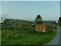
4
Buildings at Greenside Head on south side of Greenside Lane
Image: © Roger Templeman
Taken: 15 Sep 2022
0.06 miles
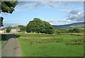
5
Footpath from Greenside to Ravenstonedale
Image: © Roger Templeman
Taken: 15 Sep 2022
0.11 miles
10
Low Greenside Farm
Viewed from the public bridleway running to the north of the farm.
Image: © Stephen Craven
Taken: 23 Jun 2009
0.18 miles