IMAGES TAKEN NEAR TO
North Stainmore, KIRKBY STEPHEN, CA17 4EA
Introduction
This page details the photographs taken nearby to CA17 4EA by members of the Geograph project.
The Geograph project started in 2005 with the aim of publishing, organising and preserving representative images for every square kilometre of Great Britain, Ireland and the Isle of Man.

There are currently over 7.5m images from over14,400 individuals and you can help contribute to the project by visiting https://www.geograph.org.uk
Image Map
Images are licensed for reuse under creativecommons.org/licenses/by-sa/2.0
Notes
- Clicking on the map will re-center to the selected point.
- The higher the marker number, the further away the image location is from the centre of the postcode.
Image Listing (9 Images Found)
Images are licensed for reuse under creativecommons.org/licenses/by-sa/2.0
Image
Details
Distance
3
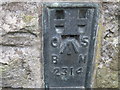
Ordnance Survey Flush Bracket 2314
This bracket can be found on the wall of Blackmoor Green Farm.
For more detail see : http://www.bench-marks.org.uk/bm872
Image: © Peter Wood
Taken: 4 Jun 2012
0.14 miles
4
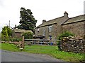
Blackmoor Green Farm
Possibly a farmhouse conversion
Image: © Les Hull
Taken: 7 Mar 2016
0.14 miles
5
Sheep in field on NW side of B6276 above Wellhead Sike
Image: © Roger Templeman
Taken: 15 Mar 2022
0.18 miles
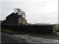
6
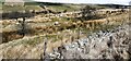
Field descending to Wellhead Sike
The B6276 crosses between Brough and Lunedale/Teesdale; this view is from that road. The nearer field with rushes descends to the groove of Wellhead Sike.
Image: © Trevor Littlewood
Taken: 12 Oct 2012
0.21 miles
7
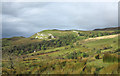
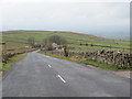
B6276 heading NE near Well Head
Ordnance Survey documents indicate that a benchmark was levelled at 312.677m above Newlyn Datum in 1974 on a stone at the base of the wall 15m from the fence/wall junction seen in this image
Image: © Roger Templeman
Taken: 15 Mar 2022
0.23 miles
8
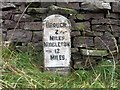
Old Milestone by the B6276, Blackmoor Gate, Stainmore Parish
Carved stone post by the B6276, in parish of STAINMORE (EDEN District), Swinging Gate, against dry stone wall, on East side of road. Brough hand stone, erected by the Brough & Middleton turnpike trust in the 19th century.
Inscription reads:-
BROUGH
2 {small hand}
MILES
MIDDLETON
{small hand} 12
MILES
Grade II Listed. List Entry Number: 1144859
https://historicengland.org.uk/listing/the-list/list-entry/1144859
Milestone Society National ID: WE_BGMT02.
Image: © C Smith / G Farrington
Taken: 18 Sep 2007
0.23 miles
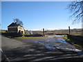
9
Road (B6276) at the entrances to Greena and Blackmoor Gate
Looking south-westward.
Image: © Peter Wood
Taken: 1 Apr 2017
0.25 miles