IMAGES TAKEN NEAR TO
North Stainmore, KIRKBY STEPHEN, CA17 4DZ
Introduction
This page details the photographs taken nearby to CA17 4DZ by members of the Geograph project.
The Geograph project started in 2005 with the aim of publishing, organising and preserving representative images for every square kilometre of Great Britain, Ireland and the Isle of Man.

There are currently over 7.5m images from over14,400 individuals and you can help contribute to the project by visiting https://www.geograph.org.uk
Image Map
Images are licensed for reuse under creativecommons.org/licenses/by-sa/2.0
Notes
- Clicking on the map will re-center to the selected point.
- The higher the marker number, the further away the image location is from the centre of the postcode.
Image Listing (5 Images Found)
Images are licensed for reuse under creativecommons.org/licenses/by-sa/2.0
Image
Details
Distance
1

Field on east side of minor road
A green field with other fields beyond showing rougher grazing.
The upland area beyond appears to be named as Scarth.
Image: © Trevor Littlewood
Taken: 25 Mar 2019
0.17 miles
2
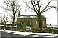
North Stainmore Chapel
The building appears to straddle the gridline, with the front wall and left half just within!
Image: © Bob Jenkins
Taken: 13 Mar 2006
0.23 miles
3
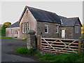
North Stainmore Village Hall
Old maps show a school on this site in 1899. The right side extension has a 1909 date stone.
Image: © David Rogers
Taken: 8 Oct 2009
0.23 miles
4
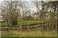
Houses at North Stainmore
North Stainmore is a small settlement just north of the dual carriageway of the A66, in fact some of the road surfaces there were surely part of the A66 before its realignment.
Image: © Trevor Littlewood
Taken: 20 Nov 2014
0.24 miles
5
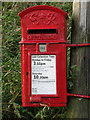
North Stainmore Postbox
GR VI box no. CA17 105 North Stainmore.
Image: © David Rogers
Taken: 8 Oct 2009
0.24 miles