IMAGES TAKEN NEAR TO
Brough, KIRKBY STEPHEN, CA17 4DX
Introduction
This page details the photographs taken nearby to CA17 4DX by members of the Geograph project.
The Geograph project started in 2005 with the aim of publishing, organising and preserving representative images for every square kilometre of Great Britain, Ireland and the Isle of Man.

There are currently over 7.5m images from over14,400 individuals and you can help contribute to the project by visiting https://www.geograph.org.uk
Image Map
Images are licensed for reuse under creativecommons.org/licenses/by-sa/2.0
Notes
- Clicking on the map will re-center to the selected point.
- The higher the marker number, the further away the image location is from the centre of the postcode.
Image Listing (14 Images Found)
Images are licensed for reuse under creativecommons.org/licenses/by-sa/2.0
Image
Details
Distance
1
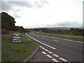
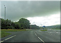
A66
A66 1 mile E of Brough looking eastwards
Image: © Alexander P Kapp
Taken: 25 Oct 2006
0.02 miles
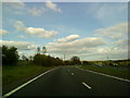

5
A by-passed section of the old A66 road
Looking south-eastward. The road to the right now joins the current A66 dual carriageway Brough By-pass.
Image: © Peter Wood
Taken: 1 Apr 2017
0.10 miles
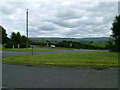
7
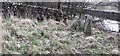
Orphaned gateposts near Ghyll Brow north of A66
Image: © Roger Templeman
Taken: 15 Mar 2022
0.13 miles

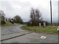
9
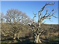
Trees beside footpath
Looking from footpath towards A66 (hidden)
Image: © colin
Taken: 2 Dec 2021
0.20 miles
