IMAGES TAKEN NEAR TO
North Stainmore, KIRKBY STEPHEN, CA17 4DQ
Introduction
This page details the photographs taken nearby to CA17 4DQ by members of the Geograph project.
The Geograph project started in 2005 with the aim of publishing, organising and preserving representative images for every square kilometre of Great Britain, Ireland and the Isle of Man.

There are currently over 7.5m images from over14,400 individuals and you can help contribute to the project by visiting https://www.geograph.org.uk
Image Map (Loading...)


Getting Data...Please wait
Leaflet Map data © OpenStreetMap
Images are licensed for reuse under creativecommons.org/licenses/by-sa/2.0
Notes
- Clicking on the map will re-center to the selected point.
- The higher the marker number, the further away the image location is from the centre of the postcode.
Image Listing (7 Images Found)
Images are licensed for reuse under creativecommons.org/licenses/by-sa/2.0
Image
Details
Distance
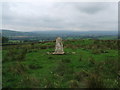
1
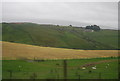
Leonard's Crag
From the side of the A66.
Image: © David Lally
Taken: 13 Nov 2008
0.00 miles
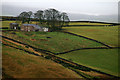
3
Leonard's Crag
A small limestone escarpment above Leonard's Cragg, an isolated farmhouse.
Image: © Bob Jenkins
Taken: 3 Mar 2006
0.16 miles
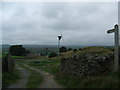
5
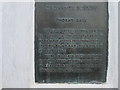
Ordnance Survey Triangulation Pillar Plaque
This plaque can be found on the trig pillar at Limes Head.
Image: © Peter Wood
Taken: 4 Jun 2012
0.23 miles
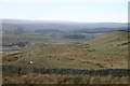
6
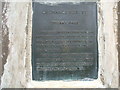
Plaque on Thorney Gale Triangulation Pillar
Image: © David Brown
Taken: 29 Aug 2008
0.24 miles