IMAGES TAKEN NEAR TO
South Stainmore, KIRKBY STEPHEN, CA17 4DH
Introduction
This page details the photographs taken nearby to CA17 4DH by members of the Geograph project.
The Geograph project started in 2005 with the aim of publishing, organising and preserving representative images for every square kilometre of Great Britain, Ireland and the Isle of Man.

There are currently over 7.5m images from over14,400 individuals and you can help contribute to the project by visiting https://www.geograph.org.uk
Image Map
Images are licensed for reuse under creativecommons.org/licenses/by-sa/2.0
Notes
- Clicking on the map will re-center to the selected point.
- The higher the marker number, the further away the image location is from the centre of the postcode.
Image Listing (16 Images Found)
Images are licensed for reuse under creativecommons.org/licenses/by-sa/2.0
Image
Details
Distance
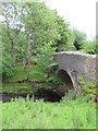
1
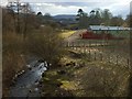
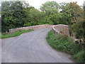
Argill House Bridge in Argill
Stone bridge leading to Argill House, just beyond the static caravans; similar to David Brown's photo of 2008, but now with a red picket fences surrounding them.
Image: © Matthew Hatton
Taken: 9 Mar 2010
0.04 miles
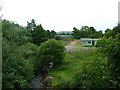
3
Bridge over Argill Beck, Brough, Cumbria
Image: © David Medcalf
Taken: 2 May 2005
0.10 miles
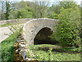
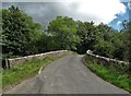
4
Argill Bridge, Barras
Beneath which flows Argill Beck.
Image: © David Rogers
Taken: 8 Oct 2009
0.14 miles
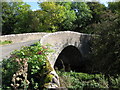
5
Argill Bridge
Spans Argill Beck near Brough.
Image: © G Laird
Taken: 28 Sep 2013
0.14 miles
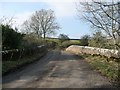
6
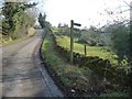
Signpost for the public footpath to Oxenthwaite
On the road from Brough to Barras, immediately east of Argill Bridge.
Image: © Christine Johnstone
Taken: 13 Feb 2017
0.16 miles
7
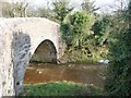
Argill Beck at Argill Bridge
The downstream [south] side.
Image: © Christine Johnstone
Taken: 13 Feb 2017
0.16 miles
9
Argill Bridge
Beneath the bridge flows Argill Beck on its way to joining the River Belah and eventually the Eden.
Image: © Gordon Hatton
Taken: 11 Jul 2020
0.16 miles
10
Argill Bridge from the east
The site of a 201 metre spot height. The beck it crosses is a parish boundary.
Image: © Christine Johnstone
Taken: 13 Feb 2017
0.17 miles