IMAGES TAKEN NEAR TO
Brough, KIRKBY STEPHEN, CA17 4DD
Introduction
This page details the photographs taken nearby to CA17 4DD by members of the Geograph project.
The Geograph project started in 2005 with the aim of publishing, organising and preserving representative images for every square kilometre of Great Britain, Ireland and the Isle of Man.

There are currently over 7.5m images from over14,400 individuals and you can help contribute to the project by visiting https://www.geograph.org.uk
Image Map
Images are licensed for reuse under creativecommons.org/licenses/by-sa/2.0
Notes
- Clicking on the map will re-center to the selected point.
- The higher the marker number, the further away the image location is from the centre of the postcode.
Image Listing (4 Images Found)
Images are licensed for reuse under creativecommons.org/licenses/by-sa/2.0
Image
Details
Distance
1
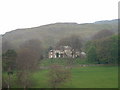
Helbeck Hall, Brough
This is a private house, which seems to have had many variations on its name over the years: Hill Beck; Helsbeck; Hillbeck; Hillebeck. Even today it is Helbeck Hall on the 1:50,000 map, and Hellbeck Hall on the 1:25,000
Image: © David Medcalf
Taken: 2 May 2005
0.05 miles
2
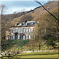
Helbeck Hall
Built in 1776 for John Metcalfe at the foot of Hall Fell. A grade II listed building http://www.britishlistedbuildings.co.uk/en-73342-helbeck-hall-with-retaining-wall-to-rear-
Image: © Karl and Ali
Taken: 13 Mar 2011
0.21 miles
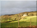
4
Sheep pastures, Helbeck
Looking towards Mallerstang Edge and Wild Boar Fell.
Image: © Karl and Ali
Taken: 13 Mar 2011
0.24 miles