IMAGES TAKEN NEAR TO
Bayside, KIRKBY STEPHEN, CA17 4BY
Introduction
This page details the photographs taken nearby to Bayside, CA17 4BY by members of the Geograph project.
The Geograph project started in 2005 with the aim of publishing, organising and preserving representative images for every square kilometre of Great Britain, Ireland and the Isle of Man.

There are currently over 7.5m images from over14,400 individuals and you can help contribute to the project by visiting https://www.geograph.org.uk
Image Map (Loading...)


Getting Data...Please wait
Leaflet Map data © OpenStreetMap
Images are licensed for reuse under creativecommons.org/licenses/by-sa/2.0
Notes
- Clicking on the map will re-center to the selected point.
- The higher the marker number, the further away the image location is from the centre of the postcode.
Image Listing (139 Images Found)
Images are licensed for reuse under creativecommons.org/licenses/by-sa/2.0
Image
Details
Distance
1
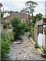
Swindale Beck at Brough
The beck bisects the village near its centre.
Image: © Gordon Hatton
Taken: 11 Jul 2020
0.01 miles
2
![Brough features [6]](https://s0.geograph.org.uk/geophotos/07/30/33/7303328_0d639998_120x120.jpg)
Brough features [6]
Swindale Beck looking downstream from the bridge that carries High Street, the former A66 road.
Brough is a village in the Eden district of Cumbria, some 21 miles northeast of Kendal and about 30 miles west of Darlington. The village is on the A66 road, a key route across the Pennine Mountains via the Stainmore Pass. Brough is on the site of the Roman fort of Verterae and has the ruins of a Norman castle. The village has historically been divided into Market Brough, to the north, and Church Brough, to the south.
Image: © Michael Dibb
Taken: 20 Jun 2022
0.01 miles
3
![Brough houses [11]](https://s1.geograph.org.uk/geophotos/07/30/33/7303337_d598da0c_120x120.jpg)
Brough houses [11]
Hazel Bank Cottage, number 6 Bridge Street, was built in the 18th century with later alterations. Constructed of rubble stone under a stone slate roof. Listed, for group value, grade II, with details at: https://historicengland.org.uk/listing/the-list/list-entry/1144908
Brough is a village in the Eden district of Cumbria, some 21 miles northeast of Kendal and about 30 miles west of Darlington. The village is on the A66 road, a key route across the Pennine Mountains via the Stainmore Pass. Brough is on the site of the Roman fort of Verterae and has the ruins of a Norman castle. The village has historically been divided into Market Brough, to the north, and Church Brough, to the south.
Image: © Michael Dibb
Taken: 20 Jun 2022
0.01 miles
4
![Brough houses [12]](https://s2.geograph.org.uk/geophotos/07/30/33/7303338_7b4df2fb_120x120.jpg)
Brough houses [12]
Inglenook, number 7 Bridge Street, was a shop, now a private house. Built in the late 18th century of coursed rubble stone under a stone slated roof. The former shop window has been removed. Listed, grade II, with details at: https://historicengland.org.uk/listing/the-list/list-entry/1137126
Brough is a village in the Eden district of Cumbria, some 21 miles northeast of Kendal and about 30 miles west of Darlington. The village is on the A66 road, a key route across the Pennine Mountains via the Stainmore Pass. Brough is on the site of the Roman fort of Verterae and has the ruins of a Norman castle. The village has historically been divided into Market Brough, to the north, and Church Brough, to the south.
Image: © Michael Dibb
Taken: 20 Jun 2022
0.01 miles
5
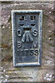
Benchmark on Brough Old Bridge
Ordnance Survey flush bracket (serial number 11753) benchmark described on the Bench Mark Database at http://www.bench-marks.org.uk/bm639
Image: © Roger Templeman
Taken: 30 May 2015
0.02 miles
6
Southwest parapet of Old Bridge, High Street
There is an OS flush bracket benchmark Image on the left hand parapet pier
Image: © Roger Templeman
Taken: 30 May 2015
0.02 miles
7
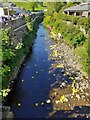
Swindale Beck, Brough
Duck race, Queen's Platinum Jubilee
Image: © colin
Taken: 4 Jun 2022
0.02 miles
8
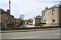
Shop on corner of Bridge Street, Brough
Sign above the door says: 'Wilkinson Bros., Gents Outfitters, Established 1810'.
Image: © Andrew Curtis
Taken: 20 Jul 2015
0.02 miles
9
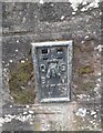
Ordnance Survey Flush Bracket (11753)
This OS Flush Bracket can be found on the SW parapet of the Old Bridge. It marks a point 181.145m above mean sea level.
Image: © Adrian Dust
Taken: 28 Oct 2023
0.02 miles
10
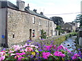
Swindale Beck, Brough
Attractive old stone cottages line the beck in the old coaching town of Brough.
http://www.thecumbriadirectory.com/Town_or_Village/Brough/Brough.php
Image: © Colin Smith
Taken: 28 Aug 2009
0.02 miles