IMAGES TAKEN NEAR TO
High Street, KIRKBY STEPHEN, CA17 4BX
Introduction
This page details the photographs taken nearby to High Street, CA17 4BX by members of the Geograph project.
The Geograph project started in 2005 with the aim of publishing, organising and preserving representative images for every square kilometre of Great Britain, Ireland and the Isle of Man.

There are currently over 7.5m images from over14,400 individuals and you can help contribute to the project by visiting https://www.geograph.org.uk
Image Map
Images are licensed for reuse under creativecommons.org/licenses/by-sa/2.0
Notes
- Clicking on the map will re-center to the selected point.
- The higher the marker number, the further away the image location is from the centre of the postcode.
Image Listing (135 Images Found)
Images are licensed for reuse under creativecommons.org/licenses/by-sa/2.0
Image
Details
Distance
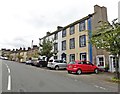
2
![Brough houses [8]](https://s1.geograph.org.uk/geophotos/07/30/33/7303333_0b1af35a_120x120.jpg)
Brough houses [8]
Bank House, High Street, comprises a cottage and one bay of Glaslyn House Image dated 1769. Constructed of stuccoed rubble stone with incised lines to give the appearance of ashlar, with freestone dressings, all under a graduated slate roof. Listed, grade II, with details at: https://historicengland.org.uk/listing/the-list/list-entry/https://historicengland.org.uk/listing/the-list/list-entry/1144914
Brough is a village in the Eden district of Cumbria, some 21 miles northeast of Kendal and about 30 miles west of Darlington. The village is on the A66 road, a key route across the Pennine Mountains via the Stainmore Pass. Brough is on the site of the Roman fort of Verterae and has the ruins of a Norman castle. The village has historically been divided into Market Brough, to the north, and Church Brough, to the south.
Image: © Michael Dibb
Taken: 20 Jun 2022
0.02 miles
3
![Brough houses [7]](https://s0.geograph.org.uk/geophotos/07/30/33/7303332_9b2d1ec5_120x120.jpg)
Brough houses [7]
Glaslyn House, High Street, and Bank House Image were originally one house, dated 1769. Constructed of stuccoed rubble stone with incised lines to give the appearance of ashlar, with freestone dressings, all under a graduated slate roof. Listed, grade II, with details at: https://historicengland.org.uk/listing/the-list/list-entry/1137172
Brough is a village in the Eden district of Cumbria, some 21 miles northeast of Kendal and about 30 miles west of Darlington. The village is on the A66 road, a key route across the Pennine Mountains via the Stainmore Pass. Brough is on the site of the Roman fort of Verterae and has the ruins of a Norman castle. The village has historically been divided into Market Brough, to the north, and Church Brough, to the south.
Image: © Michael Dibb
Taken: 20 Jun 2022
0.02 miles
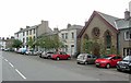
5
![Brough houses [6]](https://s3.geograph.org.uk/geophotos/07/30/33/7303331_20478a55_120x120.jpg)
Brough houses [6]
Numbers 1 and 2 Grove Cottages, High Street, were built in the late 18th or early 19th century. Constructed of pebbledashed rubble stone under a graduated slate roof. There is a through passage between the two cottages. Listed, for group value, grade II, with details at: historicengland.org.uk/listing/the-list/list-entry/1137169 (Number 1) and at: https://historicengland.org.uk/listing/the-list/list-entry/1326988 (number 2).
Brough is a village in the Eden district of Cumbria, some 21 miles northeast of Kendal and about 30 miles west of Darlington. The village is on the A66 road, a key route across the Pennine Mountains via the Stainmore Pass. Brough is on the site of the Roman fort of Verterae and has the ruins of a Norman castle. The village has historically been divided into Market Brough, to the north, and Church Brough, to the south.
Image: © Michael Dibb
Taken: 20 Jun 2022
0.03 miles
6
![Brough houses [5]](https://s2.geograph.org.uk/geophotos/07/30/33/7303330_47b65819_120x120.jpg)
Brough houses [5]
Grove House, High Street, was built in the mid 19th century. Constructed of stuccoed rubble stone with incised lines to give the appearance of ashlar under a hipped, graduated slate roof with a low parapet. Listed, grade II, with details at: https://historicengland.org.uk/listing/the-list/list-entry/1144874
Brough is a village in the Eden district of Cumbria, some 21 miles northeast of Kendal and about 30 miles west of Darlington. The village is on the A66 road, a key route across the Pennine Mountains via the Stainmore Pass. Brough is on the site of the Roman fort of Verterae and has the ruins of a Norman castle. The village has historically been divided into Market Brough, to the north, and Church Brough, to the south.
Image: © Michael Dibb
Taken: 20 Jun 2022
0.03 miles
7
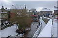
Swindale Beck, Brough
This small tributary of the River Eden flows through Brough with the car park of the Castle Hotel on the right.
Image: © Stephen McKay
Taken: 27 Dec 2010
0.04 miles
8
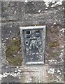
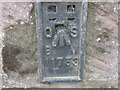
Ordnance Survey Flush Bracket (11753)
This OS Flush Bracket can be found on the SW parapet of the Old Bridge. It marks a point 181.145m above mean sea level.
Image: © Adrian Dust
Taken: 28 Oct 2023
0.04 miles
9
Ordnance Survey Flush Bracket 11753
This mark can be found on the 'old' bridge in Brough.
For more detail see : http://www.bench-marks.org.uk/bm639
Image: © Peter Wood
Taken: 4 Jun 2012
0.04 miles
10
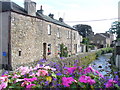
Swindale Beck, Brough
Attractive old stone cottages line the beck in the old coaching town of Brough.
http://www.thecumbriadirectory.com/Town_or_Village/Brough/Brough.php
Image: © Colin Smith
Taken: 28 Aug 2009
0.04 miles